Month: November 2009

Mountain bike Delaveaga Park Santa Cruz

Delaveaga is a large city park nestled between Branciforte Drive and Brookwood Drive north of Highway 1 on the east side of Santa Cruz. Cyclists may ride their bikes on the roads and trails within Delaveaga. The park can be very busy with different activities so watch for other users on the trail. Remember, downhill yields to uphill and cyclists are supposed to yield to walkers.

Paul @ Delaveaga

The trails are mostly redwood forest duff, with some short sections of slick limestone near “The Top of the World” (the disc golf last hole). Trail maintenance is inconsistent, so watch for fallen limbs and trees. It’s super easy to go fast on a straightaway then wash out in a sandy turn, so take it easy until you know the trails. If you crash, landings are mostly soft, though rocks, large trees and poison oak are hazards like anyplace else in Santa Cruz County. Small children and off leash dogs are very common in this park so keep your eyes open for them.

Directions: Most mountain bikers park at the lower trailhead in a dirt parking lot just north of where Market Street becomes Branciforte Drive. I usually ride my bike down Glen Canyon Rd from Scotts Valley, make a left on Branciforte (towards the Mystery Spot) and enter the ballfield area of Delaveaga.

Trails: The Redwood Loop and La Corona Trail are the main out and back trails used by mountain bikers. If you like pain, the Branciforte Trail has some steep, challenging sections. A couple of trails will take you to the golf course, and La Corona ends a the final hole of the disc golf course, so watch for people playing through. Unfortunately, as of this writing the city of Santa Cruz reorganized their website and the park trail map is no longer available.

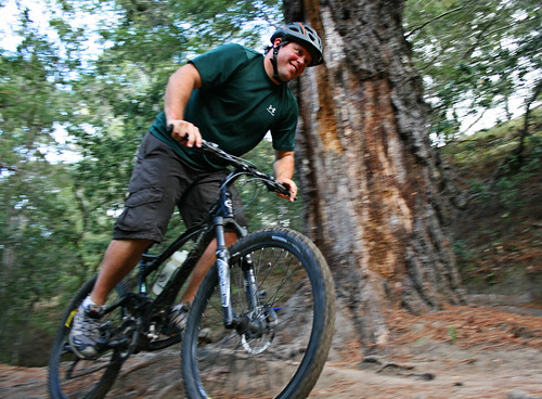
This video features Erik and his friend Paul shooting down the trails of Delaveaga on a pleasant November morning.

Follow Friday: The cost of driving

Happy Friday, all. I totally missed it’s Friday the 13th until I saw this comment.

Steve in Chicago posted thoughts and photos of damage caused by car wrecks, especially when those cars run into bike facilities. He’s asked for more photos of auto imposition, so I sent him this.

City crew replacing damaged street sign

That sign might have cost roughly $500 to replace, but this stuff adds up. There are about 6.4 million car crashes annually in the United States. Beyond the human cost of 2.9 million injuries and 40,000 deaths from these crashes, there’s a direct financial impact of $230 billion.


Rich Risemburg in Los Angeles looks at the financial benefits to commuters and businesses when you encourage cycling in Bucking the Cycle.

Is car sharing good for cities?

It’s the Department of TRANSPORTATION, not the Department of Cars.

One of many 2010 Bike Ladies Calendars.

Have a great weekend! I’ll be at the south Branci40 Dr entry of Delaveaga Park in Santa Cruz 10 AM Saturday morning if you want to say hello.

More Federal dollars for bike projects

Federal Transit Agency seeks public comment on proposed policy change for pedestrian and bicycle access projects

Local governments can apply to several programs administered by the U.S. Federal Transit Agency (FTA) to improve pedestrian and cyclist access to transit centers. Under Federal law, any capital project to enhance pedestrian and bicycle access must have a “physical or functional relationship” to the transit center.

Bike lane placement

FTA guidelines for these types of programs are vague, but a standard of 1,500 feet is generally applied — any project more than 1,500 feet away from a transit stop or station is currently not eligible. For many large stations, that barely gets you into the parking lot. The FTA now acknowledges, however, that this 1,500 distance is too short. According to the FTA, research shows people are willing to travel about 15 minutes to their bus stop or station. That equates to about 1/2 mile for walking and three miles bicycling.

The FTA proposes to expand the radius they’ll consider for grant requests: pedestrian projects can be up to 1/2 mile away; bicycle projects can be up to three miles from the transit center to receive Federal Transit capital grants. That could potentially make almost every bike facilities project in the San Francisco Bay Area eligible for FTA grant funding.

The FTA proposed this change after Transportation Secretary Ray LaHood challenged the Department of Transportation to improve the livability of our nation’s communities. A livable community, according to LaHood, is “a community where if people don’t want an automobile, they don’t have to have one; a community where you can walk to work, your doctor’s appointment, pharmacy or grocery store. Or you could take light rail, a bus, or ride a bike.” According to Secretary LaHood, “livable communities are mixed-use neighborhoods with highly-connected streets promoting mobility for all users, whether they are children walking or biking to school or commuters riding transit or driving motor vehicles.
Benefits include improved traffic flow, shorter trip lengths, safer streets for pedestrians and cyclists, lower greenhouse gas emissions, reduced dependence on fossil fuels, increased trip-chaining, and independence for those who prefer not to or are unable to drive. In addition, investing in a ‘complete street’ concept stimulates private-sector economic activity by increasing the viability of street-level retail small businesses and professional services, creating housing opportunities and extending the usefulness of school and transit facilities.”

To view the entire proposal and submit your comment electronically, visit regulations.gov. If this link doesn’t take you directly to the proposal, search for “FTA-2009-0052.”

Props to Nate Baird.