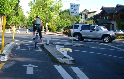
America’s first bicycle boulevard along Bryant Avenue in Palo Alto features a number of intersections that restrict motor vehicles but allow bicycles and pedestrians to pass through unhindered.
Major intersections, such as the one with Embarcadero, look like this, where cars and trucks must turn right, but bikes can continue through.
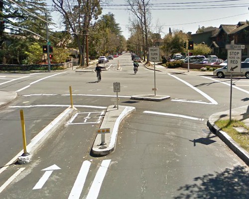
Here’s the Google Streetview at this intersection.
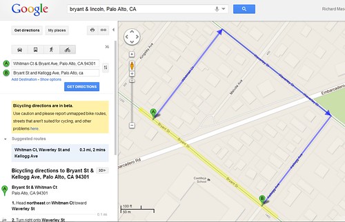
If you ask for Google bike directions, though, Google doesn’t seem to know how to deal with these bicycle-only exceptions. The simplest case is travel across a single block that crosses Embarcadero. Google tells me, as a cyclist, to detour away from the bike boulevard, up to Waverly and back south again to Bryant. I’ve highlighted the bike boulevard in yellow.
I and several other people reported this problem to the Google Maps team. I just received a response from Google.
Thank you for reporting this problem. Unfortunately, for various reasons, the problem you reported isn’t easy for us to fix at this time.
We did want to let you know that we’ve escalated your report to the appropriate engineering team. Even though we don’t have an immediate fix to your problem, please be assured that we’re working hard for a resolution.
Given that similar road treatments are becoming more common, I hope Google does engineer a way to recognize bicycle exceptions like this.
It took a bit of time for Google to add walking/biking path from downtown Norfolk Va to the Berkley neighborhood of Norfolk since the path looks like it is on an interstate. But there is a pedestrian/biking bridge as part of the interstate’s Berkley bridge. Previously Google would route pedestrians miles out of the way to the Campostella Bridge.
It’s actually not a terrible problem to have – it simply means that the physical infrastructure is evolving more rapidly than the mapping technology for a change.
can fix it yourself with google map maker!
Google Maps bike routes are mostly the result of work from city employees and individual volunteers adding details via the Google Map Maker site. When it comes to turn restrictions at an intersection, Google doesn’t make any separate distinction between allowances for cars vs bikes, so the solution to this intersection is much more complicated than it has to be. I’ll take a crack at it myself, though.
There are lots of issues with Google Maps beyond this, as they only offer classifications for “on street bike lane”, “bikes allowed but no bike lane”, or “off street trail”, but don’t offer any more specific distinction regarding sharrows, bike boulevards, cycletracks, or any other type of bike infrastructure.
I hope like other other problems Google will fix this problem very soon. And after that we can also have Bicycle directions on Google Maps