Category: transit

Google Transit integrated into Google Maps

Google announced that Google Transit has graduated from Google Labs to become a fully integrated feature of Google Maps. When you request directions in Google Maps, if transit information is available within the requested area, you can click on “Take Public Transit” to get information about public transportation for your trip.

Google Transit integrated into Google maps

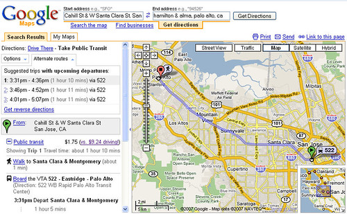
The public transit trip info includes stop location, travel time and fare, along with a driving cost comparison. Google Transit can handle connecting routes from multiple connecting transit agencies.

Although Google Transit has information on a number of U.S. and overseas transit agencies, more can certainly be added. In my area, for example, Santa Cruz Metro, Caltrain, SamTrans, SF Muni and AC Transit are all missing, among others. It’s up to the transit agency to contact Google and provide the necessary information, so contact your local public transit agency and encourage them to participate in this system. For the transit agency, the primary benefit is more visibility to casual Google Maps users of available transit options.

Via.

Wi Fi on Highway 17 Express bus begins December 2007

The Santa Cruz Sentinel reports that Hwy 17 buses to go wireless. I ride the Highway 17 Express bus from Santa Cruz to San Jose on my commute. This will be nice. Santa Cruz Metro operates this service with funding from Santa Clara VTA, Amtrak, and probably the California Air Resources Board. The Wireless Internet grant is supposed to encourage more commuter use of the Highway 17 Express bus, although all of the commute-time buses are already full.

In other news, I saw the aftermath of this bad wreck on Sunday afternoon. Traffic was backed up from near the summit all the way past my home in Scotts Valley seven miles away for the entire afternoon, and in the late afternoon the backup stretched all the way around to Highway 1 almost to Soquel Drive in Santa Cruz.

Bay Area Spare the Air August 29


Wednesday, August 29th is a Spare the Air/Free Transit day in the San Francisco Bay Area. On BART, Caltrain, the ACE train and the ferries, transit will be free until 1 PM. Transit will be free all day on Bay Area buses and light rail.

That means the train bike cars and bus and light rail bike racks will be packed full, which probably means I’ll ride my bike the entire distance to work tomorrow.

For a complete list of participating transit agencies and to plan your trip on transit, visit 511.org.

More info also at SpareTheAir.org.

Transit General Manager drives to work

Michael Burns is the General Manager of the Santa Clara Valley Transportation Authority. His annual salary is $290,000.

When he was recruited from San Francisco Muni in 2005, Burns elected not to move from San Francisco to the South Bay. Consequently, he has a daily commute of at least 50 miles.

Burns — remember, he manages a transit agency — uses his $9,000 annual car allowance to drive to work every day. Except on those days when he’s fed up with the traffic — on those days, he uses taxpayer money to pay for a room at the Holiday Inn near his office on North 1st Street in San Jose. He decides “it’s too much” to drive home after experiencing “two or three horrendous commutes.”

Here’s a radical suggestion for Micheal Burns to avoid that nasty congestion on 101 or 280: take the train! He could even drive part of the way to someplace like Millbrae, which has a huge parking lot. From San Jose Diridon, he can hop on the light rail to his office, though it might be a little faster to use the DASH shuttle to 1st and then hopped on the LRT line. From the River Oaks Light Rail station, which is served by two LRT lines, it’s a short walk to his office. He just has to walk across the big Park-and-Ride lot and he’s there.

The last Caltrain train leaves San Jose at 10:30, so there’s probably plenty of time to catch a train after those late night meetings.

Bay Area Regional Rail plans

The San Francisco Metropolitan Transportation Commission, BART, Caltrain, and the California High Speed Rail Authority are unveiling a new blueprint for expanding the system of passenger and freight rail in the San Francisco Bay Area. A series of public meetings in the area will show the proposals to move people and freight through the region in the next 50 years and describe how the regional rail network works in conjuction with the proposed California high-speed rail, along with proposed alternatives for how high speed rail will come into the Bay Area.

The San Francisco Bay Area Regional Rail website includes interactive maps that describe the regional rail network. See the website for a schedule of open houses and presentations that begin today in Oakland, San Jose, Suisun City, Livermore and San Carlos.