Tag: Caltrans

Caltrans “complete streets” update and new draft design guidance open for public comment

Caltrans HQ is proposing new design guidance (titled DIB-94) related to “complete streets” to make design for walking and biking on certain state routes easier to accomplish. These proposed changes hopefully will allow Caltrans to use updated standards for vehicle lane widths, shoulder requirements, and bike lane widths that are not part of the Highway Design Manual.

Caltrans uses their Highway Design Manual to determine the geometry of California State Routes, and includes details on lane widths, turning radii, shoulder width, vertical clearances, and so forth. Remember, a California State Route designation does not necessarily mean a limited accesss freeway. State Route 1 through Santa Cruz, for example, is known in town as “Mission Street.” State Route 82 is El Camino Real through much of the South Bay and the Peninsula in the SF Bay Area. State Route 50 is the main street across South Lake Tahoe. Large sections of SR 1 in Southern California — the Pacific Coast Highway — are used as surface roads.

Efforts to improve walking and biking on these stroads cum state highways can be difficult due to Caltrans insistence that these improvements violate their highway design standards. In December 2021, Caltrans Director’s Policy 37 on Complete Streets (DP-37) established that “in locations with current and/or future pedestrian, bicycle, or transit needs, all transportation projects funded or overseen by Caltrans will provide comfortable, convenient, and connected complete streets facilities for people walking, biking, and taking transit or passenger rail unless an exception is documented and approved.”

In conjunction with this policy, Caltrans determined that new contextual design guidance was needed to detail the minimum expectations for complete streets facilities by place type. The goals for this new design guidance are to:

  • Develop guidelines for comfortable, convenient, and connected facilities that maximize the use of the existing right-of-way by prioritizing space-efficient forms of mobility.
  • Provide minimum expectations based on context.
  • Provide additional guidance on appropriate designs, especially recommended vs minimum facilities.
  • Support streamlined design development for high volume of complete streets projects, due to new policy & funding.

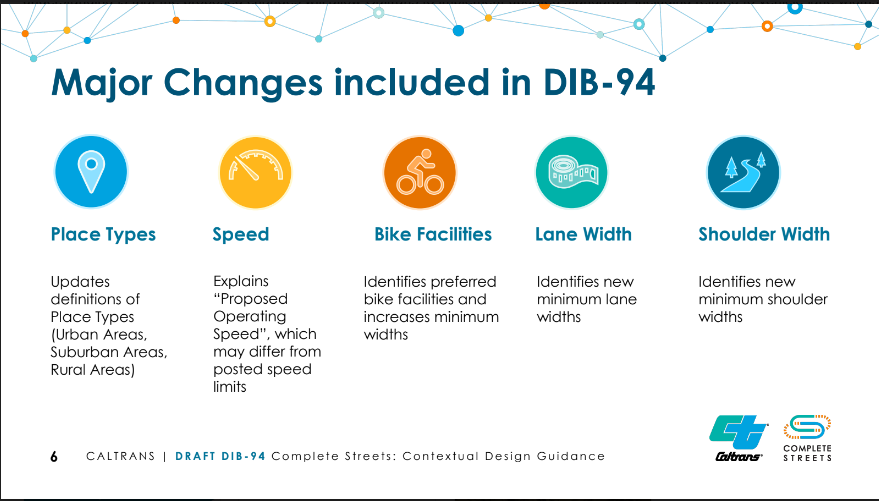
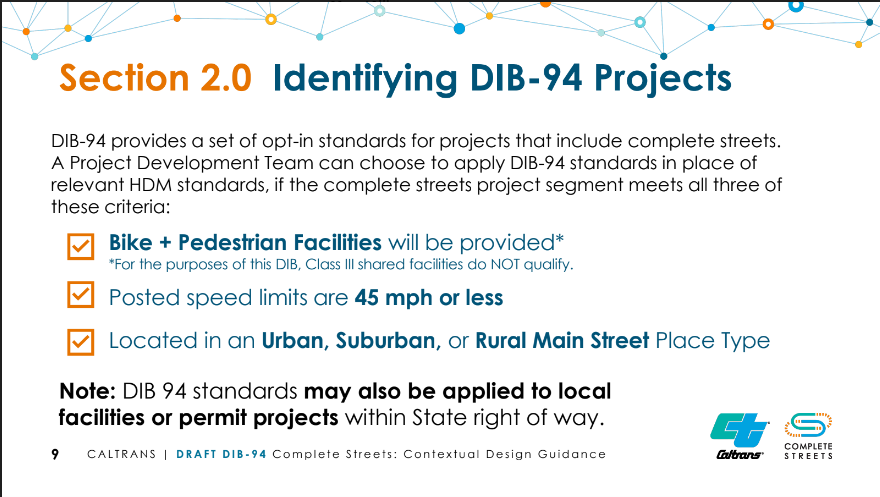
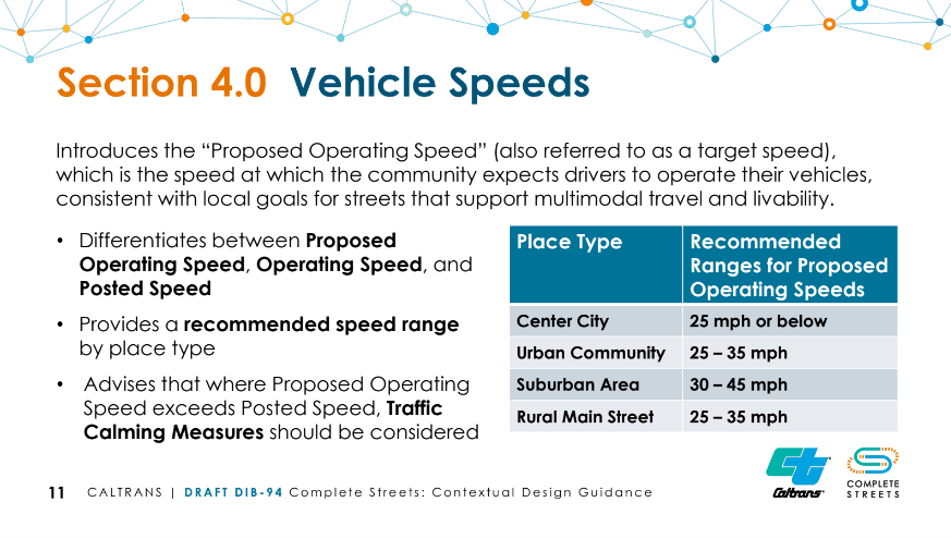
Caltrans says DIB-94 standards will apply to state routes were bike and pedestrian facilities will be provided; with speed limits of 45 MPH or less; and located in urban, suburban, or rural main street places.

To read the full draft design guidance, download and read this 71 page PDF. I know it’s a lot. To provide public comment, you have to this Excel “Comment Matrix” spreadsheet, fill in your comments, and email the completed sheet to Complete.Streets@dot.ca.gov. Public comment will be accepted through May 10, 2023.

Brigading Caltrans for safety improvements

The squeaky wheel gets the grease. After community input, Caltrans agrees to safety improvements for Highway 17 drivers, so let’s grab this opportunity to improve the shoulder along California State Route 17 from Bear Creek Road to Alma Bridge Road along Lexington Reservoir.

CHP lane splitting

Caltrans responds to petition for Highway 17 safety improvements

Caltrans is driven by data, but they also pay attention to online problem reports, especially when they see a spike in reports. I don’t know if it’s possible to game this system, but Caltrans District 4 (which covers the San Francisco Bay Area, including Santa Clara County aka the “South Bay”), responded very quickly after an effort organized on Facebook resulted in an inundation of problem reports regarding hazardous conditions on the infamous “Highway 17.

Highway 17 is the main thoroughfare between homes in coastal Santa Cruz and jobs in Silicon Valley. The highway is a winding, mountain road that rises from near sea level, up to 1800 feet, and back down to 100 feet above sea level where State Route 17 becomes I-880 at I-280. Challenging geography and budget constraints meant engineers compromised on design features when they constructed this road in the 1940s. Danger increases in wet weather.

After a decade of drought during an era of significant population and job growth, a series of atmospheric rivers slammed northern California this past winter, resulting in a dramatic increase in collisions on this highway.

Some Facebook group members organized an effort to plead with Caltrans to improve safety on Highway 17. They won’t get the significant engineering they wish for, but Caltrans did move quickly to begin smaller safety improvements, namely higher friction pavement and improved guardrails. This project covers State Route 17 from Summit Road north to Alma Bridge Road just north of Lexington Reservoir.

Rumble Strips and bicycles

Interestingly (for me), safety improvements like this come in a package, a bit like a combo meal from a fast food restaurant. The Highway 17 safety package will include shoulder rumble strips. Rumble strips are used where run-off-the-road crashes due to inattention are a problem. Those who routinely travel 17 understand inattention probably is not a problem on this road.

Nonetheless, Sergio Ruiz, who runs the Pedestrian a Bicycle Program for Caltrans D4 out of Oakland, reached out to cyclists who ride over the Santa Cruz Mountains due to the hazards of rumble strips for cyclists. Several of us pointed out that almost everybody avoids Highway 17 altogether by riding other mountain roads, so Caltrans can add rumble strips to their heart’s content.

We do have one very important exception: Several people scramble along that 4/10ths of a mile of Highway 17 from Bear Creek Road to Alma Bridge Road. 500 people have logged rides to Strava so far along this stretch of Hwy 17 during a very rainy start to 2019. Sergio assured me there are no plans to rumble strip that portion of 17.

As an aside, though, I mentioned the drainage grates and crappy condition of the shoulder forces us to move out into the auxiliary lane here.

Sergio picked up on this and said he would try to get shoulder improvements for cyclists added into this overall safety project.

Can we encourage Caltrans to leverage an existing project and add this small bit of shoulder to their much larger safety project? If you ride this short stretch of Highway 17 on your bicycle, drop a note to Caltrans PIO for
Santa Clara County, Victor Gauthier (Victor.Gauthier@dot.ca.gov) and mention that you would like the shoulder improved here as part of an existing safety project, since Caltrans has to tear the pavement up anyway.

The motoring group also contacted the California Office of Traffic Safety, Santa Clara County Supervisor Mike Wasserman, the California Transportation Commission, the office of Senator Jim Beall, and various other decision makers. I’m told some of these people received upwards of 1,000 emails, which is enough to get anyone’s attention.

Pushback on Caltrans proposal to close Skyline in Daly City

Update June 8, 2017: Your emails and phone calls made a difference; Caltrans District 4 had originally planned to install “bikes prohibited” signs on a portion of Skyline Boulevard through Daly City, California, but relented after several people who use this route told Caltrans that the suggested alternate routes on local roads are not acceptable. Although Caltrans does not have a public input process when deciding bike access on state highways, the District quickly created an ad hoc method after meeting with cycling advocates from both local and state advocacy groups.

Caltrans District 4 now seeks input from those who bicycle or are interested in bicycling on the freeway segment of State Route (SR) 35, Skyline Boulevard, across the Highway 1 interchange, or along the SR 35 corridor using local streets between Daly City and Pacifica. Please take a moment to fill out this online survey and share the link with others who may be interested. This targeted survey will help inform Caltrans in developing both short and long term strategies for people bicycling along this corridor. The survey will be available until June 25, 2017.

Find the survey at https://goo.gl/forms/zmUejriBGtBLYJzq1

Read below for the original story and background.

(more…)

Santa Cruz cyclists oppose rumble strips

Several dozen people — mostly cyclists — showed up at a Santa Cruz County Regional Transportation Commission Meeting bicycle advisory committee workshop on rumble strips. Most spoke out strongly against the Caltrans proposal to mill rumble strips into the centerline and along the shoulders of 10 miles of Highway 1 north of Santa Cruz to Davenport, California.

(more…)

Peninsula transportation consternation

Happy Friday, everybody.

A flock of seagulls supposedly knocked out power in San Mateo County this morning. Highway 101 on the Peninsula was closed near Highway 92 during the lunch hour so PG&E could repair the damaged power lines, sending lunchtime freeway traffic onto local streets. And so I ran. I ran so far away.

(more…)

Caltrans adopts Complete Streets action plan

Caltrans Director Randell Iwasaki approved a Complete Streets Action Plan on Tuesday, March 9, 2010, directing state transportation agency employees to “view all transportation improvements as opportunities to improve safety, access, and mobility for all travelers in Calfornia and recognizes bicycle, pedestrian, and transit modes as integral elements of the transportation system.”

(more…)