|
AEG revealed the route details for the 2009 Amgen Tour of California this morning. As was revealed in the Santa Rosa Democrat earlier this week, the race will start in Sacramento with a Prologue instead of a full blown stage as earlier planned. The stage from Davis to Santa Rosa becomes Stage 1.
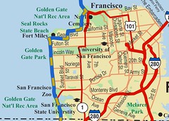
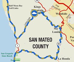
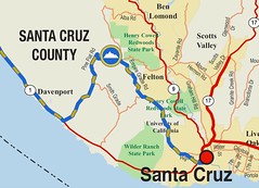
Stage 2 from Sausalito to Santa Cruz begins 8:30 Monday morning, February 16, at the Spinnaker Restaurant parking lot in Sausalito. The cyclists will cross the Golden Gate Bridge and ride through San Francisco and south along the scenic Pacific Coast Highway. Local organizers and cycling enthusiasts are excited that the route includes the locally popular Tunitas Creek Road and Bonny Doon Road hill climbs. The Stage will conclude as cyclists scream through the Redwood forest along Empire Grade Road, skirting the University of California Santa Cruz Campus and finishing at Front & Cooper in Santa Cruz near the Trader Joe’s store. I’ll post details of this and other stages later today. Download: Stage 2 Map, Stage 2 Elevation Profile. Note from Fritz: Please tweet this post. Thank you! |

|
Prologue: Sacramento (Saturday, February 14, 2009)
Start time: 1:30 p.m.
Start Location: Intersection of Capitol Mall and 9th St.
Finish Location: Intersection of L St. and 11th St.
The first day of racing in the 2009 Amgen Tour of California will be a short, but intense, individual time trial of just less than three miles, known as a Prologue. The flat and fast route will likely take each individual cyclist less than five minutes to finish. Although it is short, the Prologue will be packed with excitement and high speed. With the start and finish lines separated by only two blocks, spectators will have the opportunity to easily see the racers at both the start and finish lines. Showcasing the State Capitol, the Capitol Mall area and the well-known Tower Bridge, the Prologue will provide a crowd-pleasing day of racing excitement.
Stage 1: Davis to Santa Rosa (Sunday, February 15, 2009)
Start Time: Noon
Start Location: Intersection of C St. and 3rd St. in Davis
Finish Location: Intersection of 3rd St. and Santa Rosa Ave. in Santa Rosa
A new stage for the Amgen Tour of California, the route from Davis to Santa Rosa will provide plenty of scenic settings for both the cyclists and the spectators. Beginning in the city of Davis, which recently was named the best cycling town in the United States by Bicycling Magazine, the route includes evenly spaced climbs throughout the stage and spectacular views. After 20 miles of flat roads, the riders will meet their first climb up a short, but steep section leading up to the Monticello Dam. Another long, flat section along Lake Berryessa will take the riders to their second climb up Howell Mountain Rd., followed by a fast descent into Napa Valley. After one final climb and a steep descent from Calistoga Road, the cyclists will finish the race with circuit laps in downtown Santa Rosa. In previous years, Santa Rosa fans have set the mark for one of the largest and most enthusiastic crowds of the entire race.
Additionally, fans in Santa Rosa will have the opportunity to watch the second-annual Amgen Tour of California Women’s Criterium. Held in conjunction with Stage 1 of the Amgen Tour of California, the Women’s Criterium will begin at 1 p.m. and will showcase some of the world’s top professional women cyclists competing for $15,000 in prizes. Set as a category Pro 1/2 race, the Amgen Tour of California Women’s Criterium will have a limit of eight riders per team. Once again using portions of the Stage 1 men’s finishing circuit in Santa Rosa, the Women’s Criterium will bring the thrill of professional women’s cycling to fans in the hours just before the men’s finish in downtown Santa Rosa.
Stage 2: Sausalito to Santa Cruz (Monday, February 16, 2009)
Start Time: 8:30 a.m.
Start Location: Spinnaker Restaurant at 100 Spinnaker Dr. in Sausalito
Finish Location: Intersection of Front St. and Cooper St. in Santa Cruz
Starting on the northern side of the San Francisco Bay, Stage 2 will cover more than 100 miles from Sausalito to Santa Cruz. The stage will begin with a scenic start in Sausalito on the water and will head south over one of the most iconic structures in the country, the Golden Gate Bridge, and then through the streets of San Francisco. The route will then take the riders west down the California coastline on Highway 1, flanked by the picturesque backdrops of the Pacific Ocean on one side and Redwood forests on the other. This coastal stage will include two long, but moderate climbs on Tunitas Creek Road and Bonny Doon Road, which will be followed by lengthy and fast descents. The sprint to the finish in Santa Cruz will provide an exciting conclusion to Stage 2 of the race.
Stage 3: San Jose to Modesto (Tuesday, February 17, 2009)
Start Time: Noon
Start Location: Intersection of San Fernando St. and Almaden Blvd. in San Jose
Finish Location: Intersection of I St. and 12th St. in Modesto
Fans of the Amgen Tour of California may recognize part of Stage 3 from the 2008 race when the cyclists traveled from Modesto to San Jose; however, in 2009, the racers will be traveling the route in reverse with several changes. Beginning with a climb that is synonymous with cycling and the Amgen Tour of California, the cyclists will head up Sierra Road (1,930 ft.) within the first five miles of the stage. This epic climb will be a defining moment in the race and will create an action-packed day of racing for the cyclists and the fans alike. After completing the Sierra Road climb, the riders will face fast and flat roads full of twists and turns (Calaveras Road alone has more than 40 switchbacks) before climbing Patterson Pass. The stage will finish with two circuits in downtown Modesto.
Stage 4: Merced to Clovis (Wednesday, February 18, 2009)
Start Time: 11 a.m.
Start Location: City Hall at the intersection of N St. and 18th St. in Merced
Finish Location: Intersection of Bullard Ave. and Pollasky Ave. in Clovis
Stage 4 will introduce two new host cities and the Sierra Mountains to the Amgen Tour of California. With four KOMs (“King of the Mountain” competitions) and several sprints, Stage 4 will be a test for the riders with consistently hilly and technical terrain. From the start in Merced to the finish in Clovis, this stage will be characterized by consistent climbing surrounded by the beautiful mountain scenery. Fans can watch the climbs, always a spectator favorite, at any of the four locations – Hwy 140, twice on Hwy 49 and Crane Valley Road. Coming to a finish in Old Town Clovis, this stage will introduce the beauty of Central California to the Amgen Tour of California.
Stage 5: Visalia to Paso Robles (Thursday, February 19, 2009)
Start Time: 10 a.m.
Start Location: Intersection of Aceqia Ave. and Church St. in Visalia
Finish Location: Intersection of Spring St. and 11th St. in Paso Robles
At more than 130 miles, Stage 5, sponsored by Rabobank, is the longest stage of the race. A new course for the 2009 Amgen Tour of California, Stage 5 will begin with a neutral start of parade laps through Visalia’s downtown area. Once the race wends its way through the start in Visalia, the riders will experience an amazing contrast between the previous day of racing in the Sierra Mountains, as they head through the vast stretch of flat roads on the San Joaquin Valley floor. For the first 100 miles of the stage, the riders will have virtually no protection from the wind, creating a challenging ride. Winding its way back to the coast, the route, which will include two sprints, will pass by vast cattle ranches and farms. Packed full of rolling hills and large horse farms, the final 30-mile run into Paso Robles will be a fast sprint to the finish.
Stage 6: Solvang Individual Time Trial (Friday, February 20, 2009)
Start Time: Noon
Start Location: Intersection of Mission Drive and 1st St.
Finish Location: Copenhagen Dr.
The quaint Danish village of Solvang hosts some of the ProTour teams annually for training camps, as well as some of the largest cycling events in the United States. With the start and finish lines located only one block apart, Stage 6 is an ideal location for spectators to view the race. The route will highlight the beautiful Santa Ynez Valley, winding through quaint towns, vineyards, farms, and one short, but steep climb up Ballard Canyon. This year’s short, flat and fast time trial will create a challenging test for the riders and is expected to be a decisive day of the race.
Stage 7: Santa Clarita to Pasadena (Saturday, February 21, 2009)
Start Time: Noon Start Location: Town Center Drive in Santa Clarita Finish Location: West Drive, alongside the Rose Bowl in Pasadena
The race from Santa Clarita to Pasadena proved to be a difficult one during the final stage of the 2008 Amgen Tour of California, and this year will be no different. The first 25 miles of Stage 7, sponsored by Herbalife, include a gradual climb from Santa Clarita, through Acton, to the intersection of Angeles Forest Road. The route continues uphill, showcasing the beauty of the San Gabriel Mountains, to the second highest elevation ever reached by the Amgen Tour of California on the towering Millcreek Summit (4,906 ft.). Descending with a 15-mile run to Angeles Crest Highway, the route begins a fast plunge to the Rose Bowl in Pasadena. After more than 65 miles from Santa Clarita to Pasadena, with the mountains and the Rose Bowl serving as the backdrop, the peloton will complete the stage with five, five-mile laps on a very demanding circuit through the area surrounding the Rose Bowl. This course will provide a challenging, action-packed day leading up to the finale on Sunday.
Stage 8: Rancho Bernardo to Escondido (Sunday, February 22, 2009)
Start Time: Noon
Start Location: Bernardo Center Dr. in Rancho Bernardo
Finish Location: Intersection of Grand Ave. and Broadway in Escondido
With the final stage of the 2009 Amgen Tour of California as a difficult point-to-point road race, there is a chance to see an overall lead change, as well as a change in the KOM jersey leader on the last day. With four climbs, including the highest point ever reached in the Amgen Tour of California, and two sprints, Stage 8, sponsored by Amgen, can easily be characterized as the most difficult final stage that the Amgen Tour of California has ever seen. The cyclists will have to fight through the very end of the race, due to the addition of Palomar Mountain (5,123 ft.). At 11.7 miles, a seven percent average grade, 4,200 feet of climbing and 21 switchbacks, Palomar Mountain will provide a challenging conclusion to the 2009 Amgen Tour of California. Organizers expect a hard sprint to the finish; as with all the Grand Tours of Europe, winning the final stage of the 2009 Amgen Tour of California is a prize coveted by the riders.


The best spectating will undoubtedly be on the switchbacks up Mt. Palomar… but I haven't been able to find any info on access, parking or road closures on the mountain road. I'm wondering if it will be possible to be a spectator there and still get back to the finish line in time to enjoy the expo.
I'm not familiar with the area… are there any plans to post directions and recommendations for spectators?
The best spectating will undoubtedly be on the switchbacks up Mt. Palomar… but I haven't been able to find any info on access, parking or road closures on the mountain road. I'm wondering if it will be possible to be a spectator there and still get back to the finish line in time to enjoy the expo.I'm not familiar with the area… are there any plans to post directions and recommendations for spectators?
@Manya, I don't know Palomar and the area around it at all — you should probably contact somebody local to that area.
I've been thinking about similar best options for the mountainous Norcal and Bay Area stages and wondering how much to cover and where. I think Twitter will probably be a good tool for that — a few of us used Twitter and direct messaging last year to let the photographers on route know when and where the racers were at.
@Manya, I don't know Palomar and the area around it at all — you should probably contact somebody local to that area.I've been thinking about similar best options for the mountainous Norcal and Bay Area stages and wondering how much to cover and where. I think Twitter will probably be a good tool for that — a few of us used Twitter and direct messaging last year to let the photographers on route know when and where the racers were at.
Manya-
I'm researching that now. My boyfriend and I are planning to try to find a spot on S. Grade Road to watch the ascent as well. If I find anything out I'll post it here.
Manya-I'm researching that now. My boyfriend and I are planning to try to find a spot on S. Grade Road to watch the ascent as well. If I find anything out I'll post it here.
Jen, thanks. If you blog your findings somewhere I'll be glad to pass the link along as well.
Jen, thanks. If you blog your findings somewhere I'll be glad to pass the link along as well.
For a Top of the Mountain viewing experience check out this:
http://www.palomarsummit.com
They have everything a race fan could ever want and they are at the summit!!!
Great food, parking, Live race coverage on Vs network and internet, fully stocked store, Amgen booth, refreshment booths and even seating along the racecourse.
Space is limited so contact them soon!
760.742.4233
For a Top of the Mountain viewing experience check out this:www.palomarsummit.comThey have everything a race fan could ever want and they are at the summit!!!Great food, parking, Live race coverage on Vs network and internet, fully stocked store, Amgen booth, refreshment booths and even seating along the racecourse.Space is limited so contact them soon!760.742.4233
Help support our local Palomar Mountain School by simply parking your car! We have spots available on Palomar Mountain (.6 miles from the summit) and in Valley Center, right on Valley Center Rd! All parking spots are available for a donation to our school. Email me for more info.
thanks,
andrew kish
kish002@hotmail
lifeonthemountain.wordpress.com
Help support our local Palomar Mountain School by simply parking your car! We have spots available on Palomar Mountain (.6 miles from the summit) and in Valley Center, right on Valley Center Rd! All parking spots are available for a donation to our school. Email me for more info.thanks,andrew kishkish002@hotmaillifeonthemountain.wordpress.com