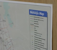
Last night I was exploring around downtown San Jose hunting for the kinds of bike routes and shortcuts that don’t appear on maps like the Silicon Valley bike map.
I happened to be thinking of bicycle shortcuts when, serendipitously, Brian in El Paso sent me a note about his post on bicycle wayfinding. He thinks of his childhood, when he and his friends traveled along creekbeds and other avenues completely invisible to those who travel by car. Official bike maps are created by planners and transportation experts who primarily think in terms of the built environment and officially sanctioned travel corridors. The use of GPS devices can help cyclists in their wayfinding, but Brian notes that projects such as Open Street Map with its user provided content can augment the cyclist’s experience beyond that provided by official maps.
This kind of local information would have been helpful during my Memorial Day visit to Sacramento. The City of Sacramento bike map gives no details on how to travel from the Amtrak station to the American River trail. There’s a “TO BIKE PATH” sign at the Amtrak station that directs cyclists up onto the I Street Bridge and back down to Jiboom Street, from which you hop over barriers to get to the trail. It’s a completely ridiculous way on a narrow, potholed road with heavy, fast traffic. A much easier but unsanctioned route exists. It turns out the entire area from the railroad tracks to Old Sacramento underneath I-5 is paved and wide open, but that information is not on any map.
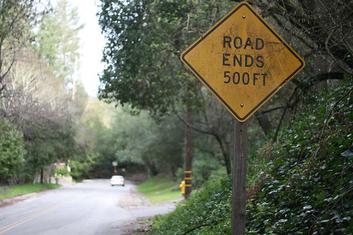
Part of the beauty and fun of cycling is traveling the path less taken. My usual route from Santa Cruz to my home in Scotts Valley, for example, does not appear on any bike map. I ride along the the Santa Cruz Big Trees & Pacific railroad right of way up to Felton, then I ride through the Mount Hermon conference center and then take a shortcut on an abandoned road (after the “Road Ends” sign shown above).
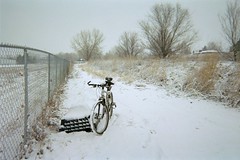 When I lived in Colorado, irrigation ditch roads were a marvelous shortcut — the snow covered ditch road shown here in eastern Longmont took a mile off of my commute route. Technically, I was trespassing, but as long as you’re not a jackass and don’t destroy their trail and their ditch, the ditch riders are generally pretty mellow about people using their facilities.
Brian has more thoughts on these ‘interstitial’ spaces that make for informal bike routes. What kinds of shortcuts do you take on a bike?
All photos by Richard Masoner.
There's a little trail I take on my way home every day. It's no more than 30 meters long but it saves me a good 5 or 6 minutes. It's just a dirt trail and there are rocks that jut up but I have ridden it so often that I can navigate the smooth line even in the snow.I got a Garmin Oregon GPS device about 4 weeks ago and I have been hunting down these kinds of interstitial points since I got it.http://bikeroutetoaster.com now uses (optionally) the Open Street Map data for autocompletion on known trails. This has become my favorite bike route mapping service–I just wish there were a way to type in a starting address rather than dragging and zooming the map.
There's a little trail I take on my way home every day. It's no more than 30 meters long but it saves me a good 5 or 6 minutes. It's just a dirt trail and there are rocks that jut up but I have ridden it so often that I can navigate the smooth line even in the snow.
I got a Garmin Oregon GPS device about 4 weeks ago and I have been hunting down these kinds of interstitial points since I got it.
http://bikeroutetoaster.com now uses (optionally) the Open Street Map data for autocompletion on known trails. This has become my favorite bike route mapping service–I just wish there were a way to type in a starting address rather than dragging and zooming the map.
Oops! I coulda told you about the railroad museum parking lot. Heck, you can just ride straight through Old Sacramento right onto the waterfront bike trail.You think I only took up riding after I moved out here but living on "the grid" I rode around quite a bit. It's such a bikeable little city, I miss it quite a bit.
Oops! I coulda told you about the railroad museum parking lot. Heck, you can just ride straight through Old Sacramento right onto the waterfront bike trail.
You think I only took up riding after I moved out here but living on "the grid" I rode around quite a bit. It's such a bikeable little city, I miss it quite a bit.
Kit: I didn't even know to ask and found it on my return to the train station. Oh well, I'll know for next time 🙂 Tommy: Thanks for the pointer to bikeroutetoaster — I didn't know about that before! Does the GPS work well in locating those hidden shortcuts?
Kit: I didn't even know to ask and found it on my return to the train station. Oh well, I'll know for next time 🙂
Tommy: Thanks for the pointer to bikeroutetoaster — I didn't know about that before! Does the GPS work well in locating those hidden shortcuts?
Different places, different problem. Here in rural western Massachusetts, my problem is the opposite: there are a lot of old farm roads that show up on maps (both old-fashioned print maps like the DeLorme atlases and modern databases like TeleAtlas) that are no longer maintained or even passable.A few weeks ago I ended up following one of those roads that petered out in a forest. I had to push my bike uphill (at an 8% grade) through a seasonal stream for a third of a mile before I got back to the road! It was kind of fun but not at all what I anticipated….Now I always use Google Earth to verify that a road really exists before I plan a route based on it.
Different places, different problem. Here in rural western Massachusetts, my problem is the opposite: there are a lot of old farm roads that show up on maps (both old-fashioned print maps like the DeLorme atlases and modern databases like TeleAtlas) that are no longer maintained or even passable.
A few weeks ago I ended up following one of those roads that petered out in a forest. I had to push my bike uphill (at an 8% grade) through a seasonal stream for a third of a mile before I got back to the road! It was kind of fun but not at all what I anticipated….
Now I always use Google Earth to verify that a road really exists before I plan a route based on it.
Brian, I can see how that could be a challenge 😉
Brian, I can see how that could be a challenge 😉
Hey,When I was a kid, I, too, used to ride off-roads, in little nature parks with trails. That was the closest thing we had to interstitial back then.Now, I'm more into the well-traveled paths, like up through the headlands in Marin Co., CA. — from SF.Anyway, I'm posting to remind all your readers about the importance of regular maintenance. I found myself with a broken chain on the wrong side of the Golden Gate not long ago. Taught me a good lesson.Wouldn't you know, the next day I read a piece online about how crucial it is to clean your bike chain. Wish I had read that the day before my run.Anybody interested in reading this can go to http://www.bikepartsplace.com. Here's the link; hope it's helpful: http://www.bikepartsplace.com/articles/how-to-clean-bike-chain-correctly/
Hey,
When I was a kid, I, too, used to ride off-roads, in little nature parks with trails. That was the closest thing we had to interstitial back then.
Now, I'm more into the well-traveled paths, like up through the headlands in Marin Co., CA. — from SF.
Anyway, I'm posting to remind all your readers about the importance of regular maintenance. I found myself with a broken chain on the wrong side of the Golden Gate not long ago. Taught me a good lesson.
Wouldn't you know, the next day I read a piece online about how crucial it is to clean your bike chain. Wish I had read that the day before my run.
Anybody interested in reading this can go to http://www.bikepartsplace.com. Here's the link; hope it's helpful: http://www.bikepartsplace.com/articles/how-to-clean-bike-chain-correctly/