The city of Santa Cruz will discuss bicycle access proposals for Pogonip city park at the regular council meeting on Tuesday, July 27, 2010. Please submit your comments to the city in support of the bike access today.
The Big Trees railroad tracks parallel to Highway 9 has historically been a favored cycling and walking route between Felton and Santa Cruz for both recreational and utilitarian uses. Because of problems with homeless camps and drug dealing on the railroad right of way and accompanying problems with property damage and public safety, however, the railroad has decided to enforce their property rights and began citing trespassers last year. Cyclists in the upper San Lorenzo Valley must now travel down Highway 9 for trips to Santa Cruz. Unfortunately, Highway 9 is now closed for construction to all traffic, leaving either the U-Conn trail with its 500 feet of elevation gain within a half mile, or a detour on Graham Hill Road. Downhill on Highway 9 or Graham Hill Road is okay, but going uphill at 4 MPH is no picnic for many cyclists, and several people I know have abandoned cycling in favor of driving because of the closed railroad access.
When Santa Cruz parks and recreation staff began drafting a new use plan for Pogonip park earlier this year, Mountain Bikers of Santa Cruz brought their proposal to the table to allow bicycle access through the infamous “Heroin Hill”.
The map below shows the existing U-Conn (“University Connector”) trail in orange, Highway 9 in teal, and the proposed bike path along the eastern edge of Pogonip in blue. Henry Cowell State Park and Felton are to the north, UCSC Santa Cruz is southwest, and city of Santa Cruz is due south of this map. Highway 9 becomes River Street in Santa Cruz.
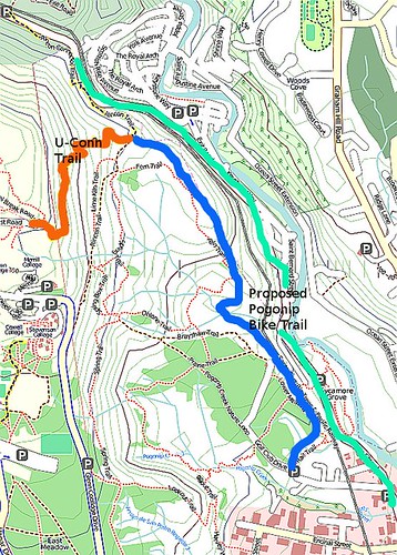
U-Conn is a switchbacked gut buster, rising from 400 feet to 850 feet of elevation in the space of about a half mile for access to the upper UCSC campus. It’s meant to provide recreational mountain biker access to the fire roads and mountain bike trails on the upper campus and Wilder Ranch State Park. For a commuter who wants to travel to work or market or Zipcar in Santa Cruz (elevation about 50 feet above sea level), this 400+ foot climb is a FAIL.
The proposed bike access across Pogonip would be wonderful for somebody like me. It provides nice, off street access for a portion of my trip into and out of Santa Cruz.
Bicycle trail opponents
Supporters of the bike access plan include equestrians, the police, and a citizen public safety group. There is significant opposition in Santa Cruz to this bike access; the local chapter of the Sierra Club are vociferously opposed to any bike access across Pogonip, with local lawyer Celia Scott making the argument that all bicyclists are scofflaws who must be kept out of city open space.
Mountain Bikers of Santa Cruz has contact information here, but you must provide your input TODAY (and apologies for the late notice!)
Great post and it's good to hear from a commute perspective. As much as MBOSC would like to take credit for this proposal it's actually the other way around. The Santa Cruz Police Department proposed the mutli-use trail to mitigate the drug activity and illegal camping in that area. The Parks and Recreation went to work on the proposal and the mountain biking community read about this proposal on the Sentinel. At first we thought that it was going to be a hiking only trail (according to the article) so we mobilized to include bikes. We were pleased to hear that multi-use was the consideration.
THanks Mark. I'll try to make it to the city council meeting — I'm gonna aim for 4 PM and hope they haven't gotten to item 19 yet 🙂