To serve the controversial Summerhill / Santa Clara Gardens development on the site of the former UC Bay Area Research and Extension Center (BAREC) near Valley Fair Mall, the city of San Jose reconfigured the intersection of Forest Avenue at Winchester Boulevard. The cities removed a signalized crosswalk to improve Level of Service across the intersection to mitigate anticipated traffic demand due to the addition of 275 housing units on the 17 acre BAREC site. What was once a reasonably bike accessible intersection to a bike friendly neighborhood street has become an ugly, bike-unfriendly juncture in what is already among the more car dependent neighborhoods of Silicon Valley.

Forest Avenue doglegs as it crosses Winchester Avenue, as you can see in the Google Satellite View above which highlights Forest Avenue. Both legs of Forest are protected with their own set of traffic lights. Although it’s not marked as such on any local bike maps, Forest west of Winchester is a favored bike route because it’s a low volume residential street. The nearby parallel roads — either Stevens Creek to the south or Pruneridge to the north — are both high volume streets with a large number of commercial driveways. Forest Ave deadends to the west at a public park, with a short path leading to a pedestrian bridge over San Tomas Expressway at Saratoga Avenue.
What goes around comes around
Santa Clara has historically had to deal with significant development impacts from their much larger neighbor. Santa Clara turned the tables with the BAREC development by planning traffic mitigations that displeased San Jose residents in the immediate neighborhood but seemed to meet the legal requirements of California’s Environmental Quality Act.
Because of San Jose’s history of flagpole annexations (See Dutch’s Panzer Division), jurisdiction along this part of Winchester is shared between the cities of Santa Clara and San Jose, complicating traffic engineering and planning efforts in the vicinity of Valley Fair Mall, Santana Row, Winchester Shopping Center and the Winchester Mystery House.
When the city of Santa Clara approved plans to develop the BAREC parcel, Santa Clara planners seemed to discount input from neighboring residents because they live in the city of San Jose. The city of San Jose at first registered their displeasure with the planned development because of traffic impacts. Because increased traffic from a brand new street, Worthington Circle, would negatively impact the Level of Service along Winchester Boulevard, planners decided to eliminate that northern traffic light and marked crosswalk. Because removing the traffic light makes left turns from northbound Winchester to westbound Forest unacceptably dangerous, a right-turn-only barrier was planted across that western segment of Forest Avenue to prevent left turns from Winchester.
And because the city of San Jose couldn’t really do anything about development in Santa Clara, they went ahead with the intersection changes proposed by their consulting engineering firm, Fehr & Peers.
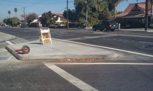
The result: the only way to access the bike-friendly route is by crossing Winchester from Forest to Worthington, then riding or walking your bike contraflow for 50 yards to Forest on a 30 inch wide excuse of a sidewalk, which includes bonus features like utility poles, street lights and street signs on the sidewalk. Because there is always pedestrian traffic on these narrow sidewalks, the only real way out is by biking against traffic on Winchester. This is a five lane road with 22,000 vehicles per day with a 40 MPH 85th percentile speed in a 35 MPH zone on 11 foot lanes. Awesome, right?
I saw a cobblestone path of sorts connecting the end of Worthington with Forest Avenue, but for now that’s fenced off.
Pay attention to those “Notices of Proposed Development”
This development first came to light in 2004. By 2007, the environmental reviews and public hearings were mostly complete. Residents of the North of Forest neighborhood tried filing a couple of lawsuits to stop the project, but by them it was mostly too late and the suits were dismissed. I live 30 miles away in Santa Cruz County, so I only noticed this changed intersection last weekend and, of course, by the time the construction has been done it’s already too late.
This illustrates the importance of watching your local planning board’s agenda. Development means more traffic, and local or regional jurisdictions may require traffic mitigation measures. The traffic mitigation for this Summerhill development choked off an important bike route, but at least it also includes a short path so bike and pedestrian access can continue after construction is complete.
That’s why I looked at plans for developments like Riverview and One South Market, both of which are in San Jose. When People Power Santa Cruz reviewed the Branciforte Creek development in 2011, the developer changed their plans to include better bike facilities and the addition of bike lanes.
Even if your city has laws requiring connections to the trail network, bike parking and showers, people in your local zoning commission may be ignorant of those laws, or they may even flat out ignore city code on bike matters. It’s up to Jane Biker to ensure Joe Developer follows the law. When it became clear that NIMBYs would lose their battle against a new Walmart Supercenter north of Longmont, CO in 2004, I reviewed the plans and discovered they didn’t meet city code for bike parking, so I demanded the four dozen bike racks next to the front door as required, and the developer acquiesced.
BPACs and other related citizen advisory committees are often asked to look at projects with a direct impact on bike facilities, but they often don’t have private development on their radar. If you see one of those big, white rectangular “NOTICE OF PROPOSED DEVELOPMENT” signs pop up on one of your regular bike routes, pay attention to where you can find the plans and look at them.
Whether they drive, bike or walk, the people living off of the west half of Forrest got screwed. They got new neighbors that will add traffic and lost half of the ways they get in and out on from Winchester. And the new neighborhood don’t even connect into the grid so they can’t use Worthington to get into the neighborhood.
It might also help to mark these critical connections as bike friendly roads on Google maps, Open Streets, etc. I don’t Forest Ave west marked as bike friendly, or maybe they already unmarked it due to its now isolated status.
I think the bike friendly road designations could use some work.
I agree, it is important to see the effects of developments and get bicycle access/issues raised early.
In this particular case the SummerHill Homes plan does show a connection from the end of Worthington circle to Forest. Not clear if this is built yet, but definitely in the plan brochure. So eventually just crossing Winchester at Worthington Forest will work for cyclists. Hopefully that will be signed well enough that cyclists will find it.
Anyone can add this to google maps via google mapmaker when it is opened.
A thirty inch sidewalk, they must be bombie, Its a thinking right out of the fifties, when gas was at .35 cents a gallon. what a waste.