Real time trail flooding info for selected trails in the cities of San Jose, Santa Clara, Los Gatos, and Milpitas in Santa Clara County, California.
Update: Thank you so much and please keep your flood reports coming. I have the Guadalupe River Trail pretty much nailed down. I’m currently seeking time and dates for flooding on Coyote Creek under 101 (and other locations it might flood).
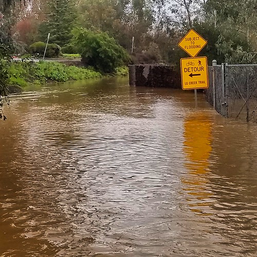
How This Works
The trail status page captures automated real-time river flow and precipitation data to predict trail flooding at selected locations throughout Santa Clara County. Updates occur hourly from 5 P.M. to 10 P.M, and again from 3 P.M. to 8 P.M. I have to limit my number of daily checks because the weather API I use costs me money. If you would like to support this effort, please browse my Amazon affiliate online store, which sorts various categories of vaguely bike-related merchandise into the previous week’s top selling items at Amazon.
The gory details for each stream
- Guadalupe River: As of this update (Feb 6, 2017) I currently report three locations for the Guadalupe River Trail across San Jose – under Highway 101 at the north end of SJC airport, under I-880 at the south end of the airport, and a vague “downtown” area, which covers the trail where it passes under major roads from San Carlos Street to East Santa Clara Street. I use the USGS stream gauge near Highway 101 to predict flooding for all locations.
During the summer, this gauge normally reads around 5 to 5.5 feet deep. For anything over seven feet, the trail under the Green Island Bridge and Highway 101 is underwater. Because of urban runoff from non-porous paved surfaces, even a few hundredths of an inch of rain is enough to flood the trail under Highway 101. For northbound detours, go east on Airport Parkway to North 1st Street, where you can ride with fast and heavy traffic in reasonably wide and clear bike lanes. The other detour is to continue north on Airport Boulevard past long-term parking, toward the taxi waiting area, and continue through the road barrier onto Ewert Road (yes, bikes are allowed here, I asked). Ewert takes you to where Central Expressway ends at De La Cruz / Trimble. From this intersection you can either go north onto Trimble (but the Hwy 101 overcrossing is not for the faint of heart), or continue west on Central until you hit the San Tomas Aquino Trail.
If the trail is flooded until 101, you can generally count flooding under Trimble Road and Montague Expressway also.
The trail under I-880 floods when the gauge is over about 10.5 feet. Northbound detour: go east on Hedding to 1st Street, where you have 1.6 miles of “share the road” on narrow lanes until you reach the bike lanes at Brokaw Street. Your other option is Hedding to 10th, make a left where Old Bayshore crosses under I-880, then continue north on on the bike lanes on Zanker Road.
Downtown undercrossings are fairly easy to bypass on surrounding surface streets, so I leave that as an exercise for the rider.
I ride the Guadalupe River Trail daily, so the trail’s flooding predictions are probably as dialed in as I can make it. Because the trail prediction is automated, I can’t account for debris (such as the impassable debris pile on the trail under Montague Expressway January / February 2017).
- Coyote Creek: There’s not an official trail under Highway 237, but I report that location because that’s where the stream gauge (operated by the Santa Clara Valley Water District) is located. If you have a favored creek undercrossing that you think I should provide flooding status for, please leave a comment along with flooding date and time information for that location.
- San Tomas Aquino Creek: I post flooding predictions where the San Tomas Aquino Trail passes under Mission College Boulevard and at Great America Parkway. This trail is trickier to predict because the nearest stream gauge is nearly six miles upstream just north of Williams Road, where Stevens Creek dives into a culvert beneath the median for San Tomas Expressway before re-emerging four miles later at its confluence with Saratoga Creek between Cabrillo Avenue and Monroe Street.
- Los Gatos Creek: I track the Los Gatos Creek Trail under Leigh Avenue mostly to express my annoyance that the city designs a parking lot storm drain to dump directly onto the trail. People passing here with anything more than about a quarter inch of rain will get wet here.
Some lower parts of the Creek Trail through Los Gatos can be subject to flooding. I post those as “Vasona Park” on the trail status page. The photo at the top of this page shows the Los Gatos Creek Trail by Charter Oaks between Lark Ave and Netflix HQ.
- Adobe Creek: The city closes this trail during the winter, so I’m not sure it’s worth maintaining this information. Speak up if you think it’s helpful.
- Penitencia Creek: The Penitencia Creek Trail is a muddy, unusable mess during the winter even when it’s not technically “flooded,” but the crossing under I-680 will increase in importance after the Berryessa BART station opens.
- Stevens Creek: The Stevens Creek Trail in Mountain View rarely floods, but it’s an important, heavily used trail so it’s good to know when it does flood. Because flooding events are rare, my data is incomplete so I can use good reports.
Does anyone use that culvert where Stevens Creek flows under I-280 on the western edge of Cupertino?
Resources
California Nevada River Forecast Center
USGS River Flow Current Conditions for California.
Santa Clara Valley Water System Real Time Data (includes stream flows at numerous locations throughout Santa Clara County).
H/T to Roger Weeks who turned me on to this information several years ago and put the bug in my ear about this predictive trail flooding info page.
Nice idea! One thing that bothers me (less than the Stadium trail closures) is the gates being closed on the San Tomas Creek Trail, from Monroe to the north, well before or after any real flooding. Would be nice if there was a way to know before I get to the gate and mutter some colorful words 😉
Huh, they never used to close the gates. Before the stadium construction began you’d learn about any flooding by bracing for ‘cyclocross mode’ while barreling down the underpass grades…
I had asked about posting notices of gate closures due to flooding at a BPAC meeting. But the standard answer was that the folks closing the gates are not smart enough to be able to update any sort of web page. One would think that they could at least send out a Tweet or the person who directed the worker(s) to close the gates would be able to trigger a web page update. And yes, it seems they take a shotgun approach and shut almost all the gates even ones where the trail level is quite high above the water level, especially at the southern end of the trail. But then again, I’ve seen gates open and the trail under water. There is also a Saratoga Creek water level station, although it is way upstream:
– http://waterdata.usgs.gov/nwis/uv/?site_no=11169500
Saratoga joins San Tomas Aquino Creek right before Monroe, so drains a different water shed. Never found a good water level station for San Tomas Aquino.
Maybe the folks closing the gates are not Webmasters, but I wonder who makes the closure decisions…My (politically incorrect) preference is to post bigger warning signs and measuring sticks and eliminate the gates.
I thought I heard at one time that you could call a phone number for (automated?) gate closure info for Santa Clara. Does anyone know anything about that?
I considered the Saratoga Creek water gauge for STAC, but the difference between dry days and rainy days is only two inches. Compare against the Guadalupe River station, which is currently five feet higher than normal. We could probably make a reasonable guess about lower trail flooding just with how much rain fell. I rarely ride STAC Trail, but if somebody has a history of trail flooding days I can correlate to rainfall and shoot automated trail info about San Tomas Aquino too.
I also grab that info through another API and use that to guess flooding on the Guadalupe River Trail even if the river level itself is low. Here’s what happens: runoff from Highway 101 above the trail drains onto a dry part of the river channel. The resulting mud flows onto the trail instead of into the river. Anything above about a quarter inch of rain results in three or four inches of mud on the trail below Highway 101.
Additional TODOs:
* Create a web page with current trail status so you can just check that page instead of hunting for an automated tweet that was sent at 6 AM.
* Check water level multiple times per day but only send a tweet out twice daily and only if conditions change.
* Add more trails.
* Keeping a history of flooding – would this be useful? Let me know.
From the amount of wrangling it took, by myself and likely others, to get the city to put up the trail closure information for stadium events, I get the impression that making updates to the city web site is a very difficult process. The city traffic engineering person hinted at that by saying they only wanted to update that closure information once a year or so. That is why the current closure information only runs until the end of the year.
Not sure about the automated phone number, I tried using one of the trail/park dept. e-mail addresses to ask about the trail, but never got a reply. Maybe at the next BPAC meeting, if I can make it, I’ll ask what criteria they use for closing the gates. At times, it seems to be based upon rainfall forecasts. Especially over weekends with rain forecast, I’ve seen the gates get closed Friday night and not get open until Monday morning. Then other times, I’ve seen gates wide open and the trail under water a foot.
Maybe if this is a more normal wet season, we can get some good closure vs. rainfall data, I don’t recall if I saw the trail closed due to flooding last year. There are a few of the underpasses that get covered in mud when the water quickly rises and falls, especially on the north end of the trail.
Update about this — I now post current trail conditions to http://www.cyclelicio.us/trails/santaclaracounty.html
Right now, I check Guadalupe River, Los Gatos Creek, San Tomas Aquino, Coyote Creek in Milpitas, and Adobe Creek in Palo Alto. If somebody has flooding history for other creekside trails in Santa Clara County please let me know and I’ll try to add them.
I was coming home on the San Tomas Trail last night, and the northern half of the 101 underpass was flooded. When I got home, I checked the rain gauge ( an old mortar tub in the back yard ). Looks like it takes about 1.5 inches of rain to make it a no go.
Guadalupe trail was heavily flooded under Montague Expy today at noon.
Just wanted to let you know that I visit the Trail Conditions page every time it rains. It’s very much appreciated!
I appreciate the feedback, thank you!
1-16-2017- the Coyote Creek trial is completely flooded at Capitol. Just south and just north are also flooded.
The Guadalupe trial is flooded just north of the airport.
1/17/2017 – After the Montague overpass, the Guadalupe River trail is clear all the way to Alviso.
7:15 am 1/30/17 GRT flooded at 101 well above the curb on the right. GRT South of 101 to Palm all clear with the exception of two small puddles, one at about 1″ b/t 880 & Bedding, the other a bit south, with clear pavement on the West 1-2′ edge of the trail.
San Tomas Aquino trail all clear from Scott to 237.
10:00 AM Feb 3 San Tomas trail about 2′ above water at lowest point at Mission College, 101 underpasses, about 1′ above water at Scott underpass ( hoping this info helps the predictive flooding algorithm )
Yes, this kind of information is super helpful. Thank you.
10:00 AM Feb 7 San Tomas trail about 2′ above water at lowest point at Central underpass, about 1′ underwater at Scott underpass at south side
8:00 PM Feb 7 San Tomas trail at Scott underpass : water just barely over surface of trail on south side, deeper on north
Coyote Creek Trail at Capitol Expressway underpass about 4 ft underwater
10:00 AM Feb 8 San Tomas at 101 underpass : water about 1.5 feet below trail at north ( deep ) end
Dear Anonymous, thank you for these detailed San Tomas Aquino Creek reports. Because of how this creek’s flows are measured flood prediction is pretty tricky, so your time and location details are helpful.
San Tomas was above water this afternoon, Water at Scott was less than a foot from the trail. Lots of greasy mud on most of the underpasses, so take it slow. Also saw the levee around the holding pond past the end of San Tomas (@237) is washed out around the back side, so that little loop is impassible now.
A section of Los Gatos Creek Trail under Highway 85 is flooded (~1-2 ft of water), as are parts of the trail under Lark Avenue. Saw this around 5:30 pm, 02/08/17.
8:00 PM Feb 8 San Tomas trail about 1′ above water at lowest point at Scott underpass, about 2′ above water at 101 underpass, Mission College, Tasman, Great America, Old Alviso all well above water.
A thought that occurred to me : I used to commute on the Guadalope River Trail from north of 237 to the airport. In spring, it was important to keep track of the king tides, because the Tasman underpass could flood just with the tidal flow. They’ve since raised it, but it might be a factor to consider in the far north trail underpasses.
Thank you! This is very useful!
San Tomas Aquino Trail, today (between 4:30-5:00pm): Impassable underpass at 237.I did detour and took Lafayette St. to connect to trail again via Agnews Rd. Flooding under 101, passed but risky, I don’t think is going to stay low for long…. Some of the remaining underpasses with high levels of water but you have the option to cross over the streets.
7:45 PM Feb 9 2017 Scott underpass submerged. 101 underpass is deeper on the north side. Water covered about 1/4 of the underpass. It was about 8″ at deepest, tapering to nothing at about half way under the northbound span of 101. Tracks showed where a couple of bicyclists had come through the water.
9:45 AM Guadalope River Trail 237 Underpass paved ( east side ) water same height as roadbed Mud 1-2″ thick: Tide level ( http://tides.mobilegeographics.com/locations/2192.html ) 0 feet
10:45 AM Guadalope River Trail 237 Underpass unpaved ( west side ) water 1 foot below roadbed Mud mostly dry: Tide level ( http://tides.mobilegeographics.com/locations/2192.html ) 9 inches
I did the whole San Tomas Aquino trail today, then into the Bay Trail through the easternmost Slough loop, 3-5:30pm.
San Tomas Aquino is dry as a bone! Most of the underpasses do have some silt where there *were* water flows, so, turn/brake/bank with care. But otherwise, looking good. 😉
The section of Bay Trail I did – San Tomas through the first Slough loop – reasonably clear. Some muddy spots, take the high road wherever the trail splits. On the Slough loop itself, just a couple of soft spots, one that I walked through but as I did, realized I probably didn’t need to. The bigger obstacle there is that the grass is so tall over the single-track, it’s hard to see the trail at times or what debris/animal/portal to another dimension might be lurking under my tires.
But, there you have it! Thanks for this page, very helpful!
2/17/17 @~12 PM PDT: Los Gatos Creek highly flooded; water level visible from bedroom window, ~300 feet from recessed creek trail, which has been almost completely filled in to parking lot level again. Constant rain ongoing
Feb 18 8:30PM San Tomas Creek Trail
Scott underpass : south side water barely over the top of the trail directly under the guardrail, north side is deeper
101 underpass : about 1.5 ‘ above water surface at lowest point
Mission College underpass : about 1.5 ‘ above surface of water, layer of mud, so it was probably covered earlier
Tasman : well above water, even dry in places
Coyote Creek Trail, South: The trail is flooded under the 81/101 flyovers south of Bernal Road. Fast moving water among the freeway support structures. Low visitbility. No way through, so don’t go down there. 5:06pm Tues Feb 21 2017
Feb 22 Guadalupe
101 underpass flooded
880 underpass – no longer flooded but thick layer of mud in the paths around it as well as debris from where the flood level was at
San Tomas Aquino Trail: clear and dry all the way ( from 237 underpass until the end). Today at 5pm.
Guadalupe trail at Julian Street ~6″ of water. For 75 yards to the south ~ 2″ of mud. Puddles and mud between 880 and Taylor.
Coyote Creek clear and dry from Dixon Landing to 237. 2/23 AM.
Guadalupe Trail underpasses at Montague and Trimble are still flooded as of the evening of 2/23
Guadalupe at San Fernando underpass 2″ of water & 75 yards of 1″ mud to the South. Road the upper trail through Adobe and dealt with traffic on Park & San Fernando as I headed North this morning. Ponding and some muddy spots between Coleman and 880.
LG Creek Trail is Underwater North of Lark pedestrian bridge. Using Charter Oaks until it dries out. I often use Charter Oaks as it is straighter and better paved, even when this section of the trail is open. The trail North to Willow Street is open without debris.
Thanks for this. I’ve wondered if this part of the trail by Charter Oaks is still underwater.
Guadalupe going under the Montague Expressway was still under about 6 inches of water. It also had trees across it at both ends of the underpass.
As of 3/11/17 at 9:30a.m.
Guadalupe Trail: Tasman is clear. The water level has receded at Montague, but there is still a considerable amount of sediment and debris (including a large tree blocking part of the trail). Trimble is clear of water, with moderate sediment. 101 overpass has 2-3 inches of standing water and mud – road cyclists be very cautious (MTB probably fine).
San Tomas Aquinas: Clear of water and sediment from Monroe to Tasman.
Guadalupe Trail:
Tasman – clear
Montague – no water, but considerable debris and sediment (Large tree partially blocking trail)
Trimble – no water, moderate sediment
101 – 2 to 3 inches of standing water and mud below overpass.
San Tomas Aquinas Trail:
clear from Monroe to Tasman
Thanks for the report. You might have *just* missed our trail clearing party under Montague today! 20 of us came out and completely cleaned up the GRT there. It looks great now.
I had hoped to clean up the mud under Trimble today too but we ran out of steam after chopping up the mess under Montague.
Water on the trail under 101 is above the river, but it can’t drain because of a gravel bar between the trail and the river. A few of us dug ditches across that shoal with hand tools but what we really needs is an excavator to remove that pile of mud and gravel.
The city will clear the downtown and central portions of the trail (from Woz Way to 880) this coming week. They say they’ll figure out what to do about 880 and north after that.
Thanks for this. Ran into all sorts of challenges on the trails lately.
Kudos to San Jose for clearing GRT Woz to San Fernando… particularly San Carlos to San Fernando. Hosing off the remaining dirt is very helpful. Could use this same ‘love’ at Skyport. Hoping the forecasted rains don’t dirty everything up again…
Thanks all the cleaning efforts!! I have been avoiding Guadalupe Trail because I know the trail is full of surprises. This gives me more confidence to ride it again.
Biked to work on the Guadalupe Trail today – so great to have this status update available!
4/9/17 Coyote Creek Trail is completely flooded just north of Bailey, about 6.5 miles from the visitor center off of Cochran in Morgan Hill. But there is a work-around – go East over the Bailey overpass and take Malech (parallels 101) North to Metcalf, just past the PG&E station, where you can link up to the trail again. (The trail is also flooded on the southern edge of Coyote Ranch.)
The trail is also clear from Metcalf up to Hellyer park. Don’t know about north of there.
Thanks so much for doing this website…
guadalupe @ montague was too deep (mid calf) to be passable this morning – had to back out and cut on to montague to get on the other side of the trail. green island was high but relatively passable – it won’t be if we get the dousing we’re supposed to get on sunday.