Yesterday, I linked to Elisa Poteat’s request for bike path traffic reports.
I call upon all traffic reporters in major cities in the U.S. and U.K. to make a New Year’s resolution to report conditions for cyclists. We know that that we need to increase the number of bike commuters and diversify the crowd that is already commuting. You need a younger audience if you want to survive. So it is in our mutual interest to have bike condition reports.
Her context is the winter storm slamming the U.S. East Coast right now, but a local cyclist reminded me that these condition reports can be helpful for Silicon Valley as well. Eric W wrote:
I do think some kind of condition announcements would be good for cyclists. The underpass for 101 on the Guadalupe Trail for one. It’s not legal for me to pick up my bike and go over the roadway… Major washouts if any on trails would be good to announce.
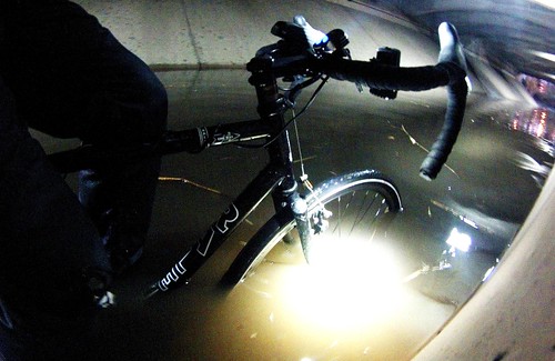
That’s a photo of me and my bike underneath Highway 101 on the Guadalupe River Trail last November. On the one hand, I think most of us know that this underpass gets flooed with every rain fall, but it indeed would have been good to know about this before I committed myself to riding here.
Instead of a traffic report, what about a collaborative, crowd sourced social media trail condition report? I have in mind something like the model used for Caltrain status updates on Twitter.
Would you participate? What type of geographical constraint should we use?
My fear: trail events are so rare in Santa Clara County that few people would see the benefit of this alert system.
Your thoughts?
San Jose trails manager Yves Zsutty will tweet trail conditions when he can and when conditions warrant, though he himself often gets the reports from other trail users. I’ve also found this active crowd sourced road conditions report by and for Minneapolis St Paul cyclists.
A lot of cyclists here in Durham, NC do that informally, particularly for the heavily traveled American Tobacco Trail. Twitter is the primary medium, with tweets coming mainly from Durham BPAC, a new advocacy group called Bike Durham and a prominent local cyclist/advocate who conveniently works at a local news station and perpetually keeps himself up to date.
Being North Carolina, our most common notifications are about storm-related downed trees & branches rather than snow or ice. And, honestly, we probably aren’t reaching anyone who isn’t experienced enough to travel the trail extra cautiously after a storm (twitter followers are self-selecting, after all). But, there are occasional surprises worth tweeting, and it generally seems like a good and appropriate way to inform the community of hazards.
You might be able to use the river monitoring station to keep track and forecast whether that crossing is flooded. http://cdec.water.ca.gov/guidance_plots/GRJ_gp.html You’d have to correlate what stage reading corresponds to the path being flooded.
Also, I would be very cautious about wading into that water. There may be all sorts of nasty stuff in there: automobile runoff, direct sewage discharge, and mercury. The last one is from Wikipedia https://en.wikipedia.org/wiki/Guadalupe_River_%28California%29#Mercury_Contamination. The first two are just me guessing.
I’d participate. One portion of my commute is on a bike path (the Arroyo Bike Path) by a “river” frequented by homeless folks. In the early morning, shopping carts block the path. But by 8 am, the carts are gone. I suspect the Parks and Recreations Department removes them, but I wish they’d do it earlier. I see lots of other cyclists on my commute in, and I think some of them would also use social media to update road conditions.
This’d be a good use case for http://blog.app.net/2013/11/21/announcing-app-net-broadcast/
Many local bike paths are used as service roads for nearby utility projects and can be closed at the whim of the utility companies (eg the Los Gatos Creek Trail and Sawyer Camp Trail). The San Tomas Aquino Trail has been under long term closure because of construction at a nearby football stadium. The Adobe Creek bike path in Palo Alto was closed for years because of construction on Hwy 101 (and is now closed again because of potential flooding). I wish there was one place to look for regional closure information; not just a Twitter feed where announcements are easy to miss.