During one of our rainstorms over this past week this tree became wedged under Montague Expressway on the Guadalupe River Trail in San Jose, California.
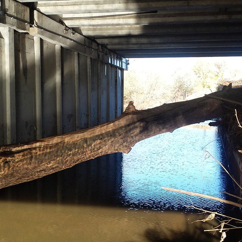
Some guy says he totally could have bypassed that with his mountain bike. The water drained by this morning, and this is what the water obscured.
San Jose Trails has sent work crews out to try to remove this tree, so far without success. They’re working to borrow heavier equipment. In the meantime, we get to detour across six lanes of fast and heavy traffic on Montague Expressway, whee!
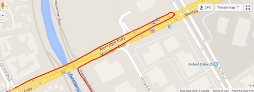
Those of you who depend on trails in the Santa Clara Valley can use this map to see real time trail conditions for paths along the Guadalupe River, Los Gatos Creek, San Tomas Aquino Trail, and lower Coyote Creek. Computer models are used to “guess” the flooding status based on automated stream flow gauges and rainfall.
This means the trail status is pretty accurate when it comes to determining how much water is on the trail, but it can’t predict things like this tree. This model also misses the heavy mud currently on the Guadalupe Trail through downtown San Jose. In spite of these limitations, I hope this tool proves useful.
I’m working with somebody to get data on the Penitencia Creek Trail in San Jose, so look for that soon.
What I really need help with is the Stevens Creek Trail, which floods under Highway 101 with heavy rain, and the Permanente Creek Trail. I never ride those trails, so I don’t know what to expect. If you’re a daily trail user on either of those trails through Mountain View, I could really use data on the days and times low spots on the trail are flooded. I can then compare against historical streamflow and precipitation data to create simple model, and then fine tune from there. Here’s video of Stevens Creek at 101 during the storm last week.
The kind people at the Friends of Stevens Creek Trail have been super helpful with some preliminary information. I’ve also called the Mountain View trail hotline for rough data, but I’d really like to know when a trail is flooded and clear within at least a four hour span. Please comment here if you think you can help out!
Permanente Creek Trail wasn’t flooded during the peak of the pineapple express. At the Rock St entrance and Old Middlefield Rd undercrossing, where the creek is a rectangular concrete channel, the water was maybe 3 feet from the top, sloshing around pretty hard, but not spilling onto the trail. Across 101 the creek has sloping “natural” banks, so the water was high but less turbulent, and still had a good buffer from the trail. I didn’t reach the Amphiteatre Pkwy undercrossing – not sure how that one faired.
Thanks for the report Lenny. That’s super helpful.
Are there parts of Permanente that are difficult during rain? Or does the trail drain fairly well?
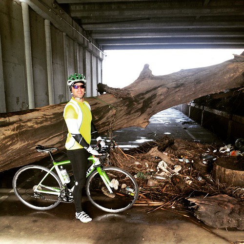
The tree is still there and it is nice to see. Yet, I can’t throw my bike over it.
Permanente seemed to drain/shed the storm rather well. Only issues lately were a tree limb that fell across 3/4 of the trail–happened a few days before stormageddon, and was cleared in a day or two–and leaves and mud accumulating at the entrance gate–just cleared this week.