Happy Tuesday the 13th. For those in the Bay Area, I hope you’re enjoying the wind and the rain.
It’s kind of an open secret among cyclists in the San Francisco Bay Area that a “Bike There” mapping option is in internal testing at Google in Mountain View. We’re pretty excited about it, even if the average speed they use to calculate trip time is 8 mph.
Recently I was looking at Google Maps for Los Gatos, California when I noticed the Los Gatos Creek Trail is in Google Maps!
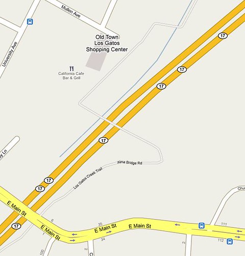
I immediately hunted around for other bike paths I know about. Coverage is spotty, even in the San Francisco Bay Area. Portions of the Stevens Creek Trail in Mountain View, for example, are missing, as is the Guadalupe River Trail in San Jose . The Oregon Expressway Bike Bridge is in Google Maps, but Ringwood Avenue is missing. The labeling of the trails is also inconsistent for now.
Elsewhere, I see trail info has been added to Boulder, Colorado but is missing from its neighbor Longmont, Colorado. (Note that the Open Street Map project map for Longmont includes the St Vrain and Lefthand Creek trails.)
Right now, the trail data doesn’t seem to be used at all for directions, even when you select “Walk There,” but Google says the trail data will be used and a “Bike There” option will be available Real Soon Now in Google Maps.
See also:
Do you see trail data in Google Maps for your area? How complete is it?


