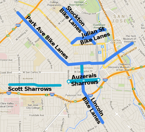
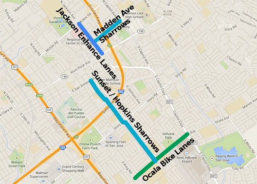
The city of San Jose DOT will hold meetings next week and the week following to discuss future bikeways in East San Jose and in the area just west of downtown. You can find an overview and meeting schedule here. Details of the planned bikeways are also now available; you can read them below the map of the west of downtown project proposals.

Downtown and West of Downtown Proposed Bike Projects
Stockton Avenue
The project will include installation of Bike Lanes on Stockton Avenue from Emory Street to The Alameda / Santa Clara Street. This work will include installation of signal detection for bicycles, as well as Bike Lane signage and pavement markings. This project will connect with existing Bike Lanes on Santa Clara Street, and planned Bike Lanes on Julian Street.
Benefits: Improves bicycle access to the Alameda business district, SAP Center, and Downtown San Jose; Improves access to the San Jose Diridon Transit Center; Improves access to Bellarmine High School.
No impacts or changes to motor traffic is anticipated.
Julian Street
The project will include installation of Bike Lanes on Julian Street from The Alameda to Almaden Blvd. Work will include installation of signal detection for bicycles, as well as Bike Lane pavement markings and signage. This project will connect with the existing Guadalupe River Trail as well as planned bikeways on Stockton Avenue and Almaden Blvd.
There’s no word on how the city plans to deal with this fun bit of Julian where it passes underneath the Caltrain tracks between Stockton and Montgomery.

Benefits: Improves bicycle access to Downtown San Jose, the SAP Center, the Alameda business district, and the Guadalupe River Trail.
Impacts / Changes: Removal of eastbound left turn lane at Cinnabar St/Keeble Ave; Removal of center two‐way left turn lane between Cinnabar St/Keeble Ave and Rhodes; Removal of eastbound right turn lane at Stockton Ave.
Scott‐Auzerais
The project will include Shared Roadway pavement markings (sharrows) and signing between MacArthur Avenue and Los Gatos Creek Trail and adding sidewalk and ADA compliant curb ramps on the south side of Auzerais between Lincoln and Sunol. In a subsequent phase, the City will install a traffic signal on Meridian Avenue at Douglas Street.
This project creates a bikeway alternative to San Carlos Street through the Burbank, Buena Vista, Del Monte, and Midtown neighborhoods and improves bicycle access to the Los Gatos Creek Trail.
Lincoln Avenue
The project will include installation of Bike Lanes on Lincoln Avenue from San Carlos Street to Willow Street. This work will include installation of signal detection for bicycles, as well as Bike Lane signage and pavement markings.
Benefits include: Provides major bikeway connection between Willow Glen and Midtown/Downtown; Provides bicycle access to Willow Glen businesses; Connects gap in the Los Gatos Creek Trail; Improves bicycle access to River Glen School.
Impacts to motor traffic include: Loss of about 20 on‐street parking spaces on Lincoln near the Auzerais Street intersection . Parking studies show utilization rates of 35% to 48% in the affected area. Loss of 30 spaces of on‐street parking along west side of Lincoln Avenue between Glen Eyrie and Willow. Parking studies show utilization rates of 61% to 70% in the affected area. Approximately 381 parking spaces are provided off‐street in the area.
Park Avenue
Park Avenue is a Primary Bikeway in the City’s Bike Plan 2020 and an important east-west connector. The project will include the installation of buffered and standard Bike Lanes on Park Avenue from Market Street to Newhall Street, the modification of signals at Park‐Sunol and Park‐Meridian, ADA compliant curb ramps at intersections between Sunol and Hedding, street light improvements, and pavement repair. This project will support a follow‐on storm water treatment project consisting of permeable pavers and bio‐retention basins.
This project creates a direct bikeway connection between Santa Clara University, the Rose Garden neighborhood, Shasta‐Hanchett Park, Midtown, and Downtown San Jose; provides bicycle access to the San Jose Diridon Transit Center and the Guadalupe River Trail; improves bicycle access to Trace Elementary School, Hoover Middle School, Lincoln High School, Rose Garden Library and Egyptian Museum.
Impacts to motor traffic include:
- Removal of a free right turn on northbound Sunol Street
- Removal of a right turn pocket on eastbound Park Avenue at Woz Way
- Shortening of the right turn pocket from eastbound Park Avenue onto Almaden Boulevard.
- Loss of on‐street parking on Park Avenue between Market Street and Sunol Street (approx 21 spaces). Parking studies show utilization rates of 68% to 85% in the affected area. Approximately 358 parking spaces are provided off‐street in the area.
- Loss of on‐street parking on Park Avenue between Sunol Street and Race Street (approx 35 spaces). Parking studies show utilization rates of 70% to 76% in the affected area. Approximately 132 parking spaces are provided off‐street in the area.
- Loss of on‐street parking on Park Avenue between Race Street and McDaniel Avenue (approx 100 spaces). Parking studies show utilization rates of 35% to 39% in the affected area. Approximately 435 parking spaces are provided off‐street in the area.
- Loss of on‐street parking on Park Avenue between McDaniel Avenue and Newhall Street (approx 12 spaces). Parking studies show utilization rates of 64% to 76% in the affected area. Approximately 261 parking spaces are provided off‐street in the area.
East Side Projects

Sunset-Hopkins
The project will include installation of Shared Roadway pavement markings (sharrows) and signing connecting the existing San Antonio Street Bike Lanes with the existing bicycle and pedestrian bridge over Route 280 at Sunset Avenue and continuing south on Hopkins Drive to the existing Bike Lanes on Ocala Avenue. The project will include installation of signal detection for bicycles, pavement markings (sharrows) and signage and an enhanced bicycle and pedestrian crossing at Story Road.
This project Improves access to the existing Bicycle/Pedestrian crossing on Sunset Ave over I‐280; Improves access to several schools, including Arbuckle Elementary, Cesar Chavez Elementary, Meyer Elementary, Lee Mathson Middle, Fischer Middle, and Overfelt High; and Creates a parallel bikeway alternative to King Road.
Jackson Avenue
The project extends the existing Jackson Avenue Bike Lanes north from Alum Rock to Madden Avenue providing a continuous bikeway connection to Madden Avenue bikeway (see below). Work will include installation of two new traffic signals with detection for bicycles, Bike Lane pavement markings and signage, and ADA compliant curb ramps.
This provides a bikeway on Jackson Avenue, a high travel‐demand corridor; Improves bicycle access to the existing Bicycle/Pedestrian crossing on Madden Avenue over I‐680; and Increases access to Regional Medical Center and future Bus Rapid Transit.
Madden Avenue
The project will add Shared Roadway pavement markings (sharrows) and signing the entire length of Madden Avenue. This project will provide a continuous bikeway connection from the San Antonio Primary Bikeway (via Jackson Avenue above) to the Madden Avenue bike and pedestrian bridge over Route 680. Work will include installation of signal detection for bicycles, as well as pavement markings (sharrows) and signage.
The Madden Avenue project improves access to the existing Bicycle/Pedestrian crossing on Madden Avenue over Highway I‐680; and creates a parallel route to Alum Rock and McKee to cross Highway I‐680.
Ocala
Project improvements include a new sidewalk to close existing gaps on the south side of Ocala Avenue, installing a new traffic signal at Adrian Way, and constructing raised median islands between Daytona and Capitol Expressway.
Ocala Avenue is a Primary Bikeway in the City’s Bike Plan 2020. This project improves access to Meyer Elementary School, Fischer Middle School, Overfelt High School, and Hillview Library; improves access to Lower Silver Creek Trail; and completes gaps in existing sidewalks and bike lanes along Ocala Avenue.
Project overview and meeting details can be found here. Watch for a story tomorrow at Streetsblog SF in which Andrew Boone digs in more detail on the near downtown projects.
(1) The details are really important here. Are these going to be the typical skinny ‘gutter’ lanes that have been often installed in the past, or the new style buffered lanes like the new ones on 1st street north of Tasman. There is huge difference between the two, as far as how much of the biking public finds them acceptable enough to use on busy roads. Whats called an enhanced bike lane needs to be the new norm, and just called a bike lane.
(2) Due to recent developments, the use of physically protected bike lanes should be considered also, where they are appropriate. These no longer require an experimental phase, which made them more expensive and time consuming in the past.
(3) Its absolutely critical that the bike lanes don’t ‘disappear’ for the underpasses, which is where they are needed the most.
(4) Finally, the removal of select pork chops and their super high radius turns should be considered at the same time as the lane installations. These force the bike lane to cross the lane of traffic while the drivers are looking in the opposite direction for traffic coming from the left. They are the source of a big bulk of VRU collisions, and have no proven LOS impact in most cases.