Real time trail flooding info for selected trails in the cities of San Jose, Santa Clara, Los Gatos, and Milpitas in Santa Clara County, California.
Update: Thank you so much and please keep your flood reports coming. I have the Guadalupe River Trail pretty much nailed down. I’m currently seeking time and dates for flooding on Coyote Creek under 101 (and other locations it might flood).
How This Works
The trail status page captures automated real-time river flow and precipitation data to predict trail flooding at selected locations throughout Santa Clara County. Updates occur hourly from 5 P.M. to 10 P.M, and again from 3 P.M. to 8 P.M. I have to limit my number of daily checks because the weather API I use costs me money. If you would like to support this effort, please browse my Amazon affiliate online store, which sorts various categories of vaguely bike-related merchandise into the previous week’s top selling items at Amazon.
The gory details for each stream
- Guadalupe River: As of this update (Feb 6, 2017) I currently report three locations for the Guadalupe River Trail across San Jose – under Highway 101 at the north end of SJC airport, under I-880 at the south end of the airport, and a vague “downtown” area, which covers the trail where it passes under major roads from San Carlos Street to East Santa Clara Street. I use the USGS stream gauge near Highway 101 to predict flooding for all locations.
During the summer, this gauge normally reads around 5 to 5.5 feet deep. For anything over seven feet, the trail under the Green Island Bridge and Highway 101 is underwater. Because of urban runoff from non-porous paved surfaces, even a few hundredths of an inch of rain is enough to flood the trail under Highway 101. For northbound detours, go east on Airport Parkway to North 1st Street, where you can ride with fast and heavy traffic in reasonably wide and clear bike lanes. The other detour is to continue north on Airport Boulevard past long-term parking, toward the taxi waiting area, and continue through the road barrier onto Ewert Road (yes, bikes are allowed here, I asked). Ewert takes you to where Central Expressway ends at De La Cruz / Trimble. From this intersection you can either go north onto Trimble (but the Hwy 101 overcrossing is not for the faint of heart), or continue west on Central until you hit the San Tomas Aquino Trail.
If the trail is flooded until 101, you can generally count flooding under Trimble Road and Montague Expressway also.
The trail under I-880 floods when the gauge is over about 10.5 feet. Northbound detour: go east on Hedding to 1st Street, where you have 1.6 miles of “share the road” on narrow lanes until you reach the bike lanes at Brokaw Street. Your other option is Hedding to 10th, make a left where Old Bayshore crosses under I-880, then continue north on on the bike lanes on Zanker Road.
Downtown undercrossings are fairly easy to bypass on surrounding surface streets, so I leave that as an exercise for the rider.
I ride the Guadalupe River Trail daily, so the trail’s flooding predictions are probably as dialed in as I can make it. Because the trail prediction is automated, I can’t account for debris (such as the impassable debris pile on the trail under Montague Expressway January / February 2017).
- Coyote Creek: There’s not an official trail under Highway 237, but I report that location because that’s where the stream gauge (operated by the Santa Clara Valley Water District) is located. If you have a favored creek undercrossing that you think I should provide flooding status for, please leave a comment along with flooding date and time information for that location.
- San Tomas Aquino Creek: I post flooding predictions where the San Tomas Aquino Trail passes under Mission College Boulevard and at Great America Parkway. This trail is trickier to predict because the nearest stream gauge is nearly six miles upstream just north of Williams Road, where Stevens Creek dives into a culvert beneath the median for San Tomas Expressway before re-emerging four miles later at its confluence with Saratoga Creek between Cabrillo Avenue and Monroe Street.
- Los Gatos Creek: I track the Los Gatos Creek Trail under Leigh Avenue mostly to express my annoyance that the city designs a parking lot storm drain to dump directly onto the trail. People passing here with anything more than about a quarter inch of rain will get wet here.
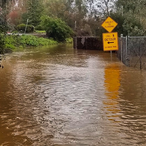
Some lower parts of the Creek Trail through Los Gatos can be subject to flooding. I post those as “Vasona Park” on the trail status page. The photo at the top of this page shows the Los Gatos Creek Trail by Charter Oaks between Lark Ave and Netflix HQ.
- Adobe Creek: The city closes this trail during the winter, so I’m not sure it’s worth maintaining this information. Speak up if you think it’s helpful.
- Penitencia Creek: The Penitencia Creek Trail is a muddy, unusable mess during the winter even when it’s not technically “flooded,” but the crossing under I-680 will increase in importance after the Berryessa BART station opens.
- Stevens Creek: The Stevens Creek Trail in Mountain View rarely floods, but it’s an important, heavily used trail so it’s good to know when it does flood. Because flooding events are rare, my data is incomplete so I can use good reports.
Does anyone use that culvert where Stevens Creek flows under I-280 on the western edge of Cupertino?
Resources
California Nevada River Forecast Center
USGS River Flow Current Conditions for California.
Santa Clara Valley Water System Real Time Data (includes stream flows at numerous locations throughout Santa Clara County).
H/T to Roger Weeks who turned me on to this information several years ago and put the bug in my ear about this predictive trail flooding info page.
Decided to ride on Guadalupe from 237 to downtown San Jose to see how it was. Still has water under Montague and 101. Passable by bike but be prepared to get wet all the way to your knees and also there is the risk of hitting any unseen debris under water….Wishing trail could be dry and clean because it felt good to ride along the river again! Taking San Tomas as usual until I hear from Guadalupe trail.
I think your feed is down. Says no data. When looking at the water levels.
trail is flooded under 101
first rain of 2022! glad to have this data available
@kjw – I’m glad people still look at this!
11/1 4:15pm Guadeloupe trail wet but passable at 101, flooded and impassable at Trimble and Montague.
It rains for two seconds and flooded! 🙁
@naa thanks for the report. I’ve tried in the past to predict flooding on the Guadalupe at Trimble and Montague, but I’ve never figured a good way to do it. I even looked at tide gauges and rainfall. I think a lot of it is dependent on how much water is discharged from the SJC airport groundwater discharge and how much debris blocks the stream.
Hey Richard! My Santa Cruz friend Bennett recently shared this project with me — it’s very cool! Which weather API are you using to power the site (e.g. that costs money)? I’m always on the hunt for interesting weather data projects, and maintain my own weather website, so curious to hear more about how this works under the hood!
San Tomas Aquino Trail had ~3ft of water under 101 at 8:30am this morning.
San Tomas Aquino Trail at Scott was clear of water at 8pm last night (1/5).
THank you to Anon for the San Tomas reports. It really helps me out.
I rode San Tomas Aquino Creek Trail this morning (1/10) at 8:10AM from Agnew to Central. The lowest underscrossings in that stretch are Scott and Mission College. Mission College was clear (just barely). Scott had about an inch of water on the trail at the undercrossing – still passable.
Guadalupe River Trail between Taylor and Hedding have several stretches of flowing water that are 6 inches or more deep. Passable if you don’t mind getting your feet wet. If you don’t mind a bit of mud, you can cut across to one of the higher paths to ride around.
Yesterday Vasona Creek at Lark was underwater at 5.53 . https://imgur.com/a/tUeqZQH#0AV8jyc. (not my pics).
Between Meridian Ave and Campbell park, the lowest point was at the Leigh underpass, and even there we had a good 14 feet to go before the path was underwater. Lincoln Ave gauge was at 9.4 feet.
Leigh underpass mainly gets wet from the storm drain that runs across. Four hours later it’s only going to be as wet as the streets.
The path between the Leigh/Blackford footbridge and Meridian is never going to flood. It’s higher than the surrounding streets. The creek would jump to a new bed (like it did in 1866).
San Tomas creek trail: no flooding today (19th) from Monroe Street to great America pkwy.
Saturday, Jan 21 at 2:30pm, Los Gatos Creek Trail between Campbell Park and Vasona. Trail is clear, although behind Netflix Campus is still totally flooded. Be careful taking the street around the trail because drivers aren’t used to all the foot traffic. I saw a cyclist almost get hit.
Hi All! I’m curious if anyone knows if the underpass under 237, Tasman, and/or Montague are dry?
Montague is still flooded.
Guadalupe Creek was open at Tasman & 237 at 4pm today. The trail was about 1ft over creek water.
Guadalupe Still flooded at Montague. About 1ft under water.
Thanks for the update! Looks like there might be some human intervention. On the 25ft it dropped by 1 ft and again today by 1/2. Otherwise it just seems to be not going down much on it’s own…
Thanks as always for the updates.
As of 30 Jan 2023, the trail has a few inches of water under 101 but is otherwise passable. The creek level is below the trail level but drains slowly due to a large gravel bar between the trail and the river. I’ll bring a shovel sometime this week to dig it out.
Trimble and Montague are both too deep to cross safely, with significant mud on the trail. At Trimble, I think the drainage path to the river is blocked by mud. At Montague, the river level is above the trail. It’s worth noting that the gravel utility road on the west bank of the river is passable at Montague, but not at Trimble.
I posted a video of yesterday’s trail conditions https://www.youtube.com/watch?v=CkyhaL2qc_w
fantastic thank you for the update! I ride Guadalupe daily and I haven’t been able to ride since December! Looking forward to getting back to Guadalupe!
Montague underpass was ok today 2/1 Trimble still flooded.
Hi Richard! Your video was very helpful, will you be updating us with another one? Any idea of when we can maybe ride the GRT again?
For folks who love the south section of the Coyote Creek Trail, (Hellyer Park down to Anderson Lake County Park), which I ride every 4-5 weeks, you can get updates on flooding conditions from the Santa Clara County Park site:
https://parks.sccgov.org/closures-updates
There are three areas of flooding – one by the velodrome, one down just south of the first 101 undercrossing south of Cottonwood Lake, and the section between Metcalf Road and Bailey Avenue. The first two look to be less than a foot deep (I rode through the second one in late January) but the third section has two places where it is maybe 5-6 feet deep with lots of debris and swift-moving water – one just south of Coyote Ranch and the other at the low-water bridge just north of Bailey Ave. It has been pretty much in the same state since late January (I was there Jan 21st and Feb 25th and have seen all of those spots in person) and it looks like it will be that way for maybe another month and a half because of the conditions at Anderson Reservoir.
You can ignore the rest of the post if that is all you want to know, but if you are geeky about these things read on…
Anderson Reservoir Dam (which feeds Coyote Creek) needs a seismic retrofit and is supposed to be no more than 3.75% full until the retrofit is complete – but all the rain we have had this winter had brought it up to 45% full in late January. They are releasing as much water as they can to bring it back down without flooding structures and roads – but that is actually causing the persistent Creek Trail flooding mentioned above. That process was expected to take a couple of months from Jan 25th as per this posting from Valley Water:
https://valleywaternews.org/2023/01/25/water-being-released-from-anderson-dam-to-maintain-3-7-storage-level/
You can actually monitor the level of the water at Anderson here:
https://alert.valleywater.org/map?p=sensor&sid=4002&disc=f
If you change the date range to track from Dec 15th to present, you can see that while the water level overall HAS gone down (as of today it’s about 34% or so), the frequent heavy rains since Jan 25th mean that it’s going take longer than originally expected.
If you hover over the data points you can see the water storage in acre-feet as of each date. You can even take the data point from Jan 25th, the date of the news item above which said the reservoir was at 45%, and Valley Water’s estimate that it would take a couple of months to bring it back down, and create a spreadsheet to estimate how many days left to get back to the required 3.75% based on the current storage (yes, I did that 🙂 ). Of course it probably won’t match real life – as they get closer to 3.75 they may back off the release rate and end the creek trail flooding sooner, past performance is no predictor of future results, and similar disclaimers.
Anyhoo, based on such calcs you can see that while it’s now down by around 10%, we probably have about a month and a half of water release (and continued Coyote Creek flooding) to go to get back down to 3.75% — assuming we don’t get more rain driving it back up (which we seem to be getting).
Tammy, thank you so much for this detailed information. I’ve been following the Anderson Dam saga and appreciate the geeky details
8AM 3/14, San Tomas Aquino Trail:
* Mission College: 1-2″ standing water (passable)
* 101: 1″ standing water (passable)
* Scott: 4-6″ rapidly flowing water (not really passable. I went for it and regret it :/)
Thanks Ben. STACT is something I really need good information on.
Note to self: stream gauge on STAC at Mission College shows 7.2 ft at 8 AM.
Adobe Creek under 101 is no longer as important because there is now a bike bridge over 101.
The Guadalupe Creek Trail is flooded at the Trimble Road underpass with deep mud. I didn’t try to cross it. The trail was passable at the 101 underpass.
Anyone know if the debris on Guadalupe River Trail has been cleared? I saw a photo on Reddit last week that it was totally blocked under Montague… getting sick of taking Central to San Tomas!
@Anon: the trail under the east bank is passable, though with dried muddy ruts. I plan to go out this afternoon with a saw and see how much I can clear on the main path.
I rode LGRT last Friday from Meridian to Main St in LG. There were 3 fence barriers in about 100 yards from Meridian that are easily bypassed. Absolutely no water or mud did I see.
I rode Lower GRT today.
From north to south:
237 underpass has a puddle that is easily dodged.
Montague Expy has a mud wall fully across the trail that is easy to portage.
Trimble is covered with water to an unknown depth. I crossed Trimble to get to the other side.
101 is lightly covered in water with an easy curb to stay dry.
Kevin
Thanks for the reports again, Kevin!
As of this last weekend, BTW, Montague was cleaned out. I plan to dig a trench at Trimble this week to drain it. If I have time I’ll dig a ditch across the gravel under Hwy 101 as well, though it’s not as urgent there.
Rode the Coyote Creek trail from Blossom Hill Road north. There are some puddles, but it’s passable until you get to the dip just before passing under 101. That’s flooded with water that’s moving fast enough to be worrisome.
Here’s some good news about the trail at Martial Cottle Park (https://parks.sccgov.org/santa-clara-county-parks/martial-cottle-park). The sccgov site has been saying “The Cooney Ranch Trail at Martial Cottle is currently closed due to flooding. This small section of trail runs underneath Highway 85 and is closed from the trailhead at Chesbro Ave/Cahalan Ave to Junction 4 at Ag Field C. ”
That was perfectly true until early June. The underpass is still wet – but it’s passable. It provides a convenient way to get under 85 – connecting the park to Cahalan and Blossom Hill Road.
Heads up that Guadalupe Trail between Coleman and Hedding will be closed Sept 13 to Dec 23, 2023.
They are installing anti-car barriers.
https://twitter.com/SanJoseTrails/status/1695119203324346857/photo/1
In early summer of this year Coyote Creek Trail was flooded (a lot of water) and closed from near Coyote Ranch, through Coyote Creek Trail Fishing Spot. We had to take a long detour on Malech Rd along the 101 to get to Morgan Hill. Does anyone know of the flood has subsided and the trail is opened?
Last week, biked the Bay Trail from Bayland Park Sunnyvale through Cooley Land Park in E. Palo Alto. All clear.
Hello all! finally back to Guadalupe after a long hiatus! Everything was clear today except at the underpass at 237 was unpassable. Happy riding!
San Tomas trail today (2023.12.20 at 8:15am) under Mission College had close to a foot of water (passable by bike, but not advisable). San Tomas under 101 had over a foot at the deepest spot, still technically passable by bike. The flooded section under 101 was shorter than the flooded section under Mission College.
San Tomas Aquino all clear, status is outdated
San Tomas trail @ Scott Blvd at 7:45am on February 6, 2024 was dry; water levels were 6-12 inches below the level of the trail, contrary to the website.
San Tomas trail @ Scott Blvd at 7:45am on February 6, 2024 was dry; water levels were 6-12 inches below the level of the trail, contrary to the website.
This evening parts of the Guadalupe River Trail were flooded with the Montague Expressway underpass at about 2.5 feet deep (which I regrettably rode through). Trimble looked just as bad and I crossed over the top. The underpass for 101 was also flooded but only about 6-inches deep. I walk d through on the curving as there’s likely slick mud underneath. Have only been riding GRT since May.:..was surprised at the depth of flooding from a quarter inch of rain.
Guadalupe River Trail north of the airport had about 3″ of water at Trimble so worth slowing down. Otherwise pretty good ride all the way to Alviso.
Hi Richard,
Thanks for the site! I rode San Tomas Aquino Creek Trail from Monroe to Mission College Blvd this morning at 8:30 and all of the underpasses were clear. At the lowest point on the trail, under 101, some dirt had been washed onto the trail but it was mostly dry. There is a Valley Water gauge at Mission College Blvd – it read 4.9 ft then. https://alert.valleywater.org/?p=sensor&sid=5122&disc=f
2/13/2025 ~10:15-10:30am
San Tomas Aquino Creek trail both mission and 101 underpass passable with no water on them. Water is below the trail by around 4 inches. 10:12&10:17am
Scott has around 1 inch of water over small sections of the trail, passable but direct path can avoid it over the bridge 10:25an
Condensa/Central is clear by 4+ feet. 10:30am
2/13/2024, ~4pm
San Tomas Aquino Creek trail both mission and 101 underpass passable with < 3" of water towards the west side of the path