Does the frequent use of U.S. Census American Community Survey (ACS) data under-represent true bike use in your community?

What is the ACS?
United States Census American Community Survey (ACS) data on “Means Of Transportation to Work” is frequently used to compare bike-usage across different American cities. Although a few cities do their own bike counts and there’s now even something approaching a standardized methodology, the ACS commuting data is often used because it’s convenient and available for every population center in the country. You can dig down to individual Census tracts or go up to ZIP code, city, county and state level, splitting populations by gender, ethnicities, commute time, income and other factors if you want.
This ACS data counts only work trips. It misses trips to shopping, coffee klatches, pub crawls, farmers market, school, errands, and recreation, whether you’re on a lazy meander, a full-on training ride, or doing something in between. Many people, myself included, strongly suspect the ACS data undercounts true bike usage in a community.
Santa Cruz traffic surveys show less bike traffic than Census surveys
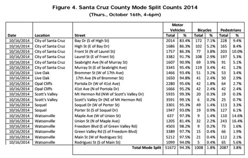
I was really surprised to see this data from the most recent bike count for Santa Cruz County, taken last October 16, 2014. At the city of Santa Cruz’s busiest intersection for bikes, bicycles made up only 7.1% of traffic between 4 PM and 6 PM, while cars constituted 83%.

Compare against the ACS 2011-2013 3-year estimate for the city of Santa Cruz, which shows 9.9% of workers bike to work. Excluding transit, work from home and the “other” category like the county does for their mode split counts, 77% drive or ride in a car and 11.4% bike to work.
The traffic count shows 7.1% bike traffic at this intersection, while the Census commute data shows 10% of city residents commute by bike. Surveys at all other locations show significantly less bike traffic when compared against the Census data.
This county bike count data goes against my expectations and has me scratching my head. The weather was clear and mild the day of the counts, but the National Weather Service records five-hundredths of an inch of rain on the previous day. Did the light mist on the day before discourage biking? Does the evening commute time frame really miss that many people on bikes? Bay and High are both popular bike routes, but perhaps bike traffic is much more dispersed city-wide, while automobilists tend to funnel onto arterials and collectors?

I’m curious about your thoughts on this. If you’re familiar with information from other cities that collect bike count data (e.g. Boulder, CO; Portland, OR; San Francisco, CA), I’m interested in how they compare against ACS bike commute data.
A couple of things:
– The state of bike/ped counting is moving beyond the documentation project, and towards more continuous automated counting. See this: http://www.trb.org/Main/Blurbs/171973.aspx
– I have a couple guesses on this phenomenon you’re noting. One is that it might be a statistical artifact- I need to flesh this idea out more, but what I’m imagining is that, if bike trips are shorter, even given the same mode share you’d expect to see fewer bicyclists at any given place (even neglecting the “commute mode share not representative” thing). Another idea is that, in Santa Cruz, a substantial proportion of cyclists are university affiliates, so there is probably some peak spreading going on, especially in the university area. Finally, the arterial concentration thing is probably not insignificant. When I lived on the Westside, I’d sometimes take Western instead of Bay to get up to campus, whereas driving I’d probably just take Bay.
If I get a chance to dig into the ACS-bike count comparison, I will. The tricky thing is very few cities have continuous automobile and bike counts at the same locations – it’s typically jsut peak hour counts on one or two days at a small sample of locations.
In general there is a high level of error in a lot of their data. I am in a particularly small town of 3,000 that has the highest bike commuter rate in the state. And that doesn’t account for our massive seasonal tourism influx of vacationers who rent thousands of bicycles every day. There’s just so little data collected that one off day could throw the entire calculation. And sadly our sample size in the ACS is so small that any conclusions based on that data is pretty much suspect.
Measuring mode share for two hours on just one day a year is just too small of a sample size to be useful. If a city wants to be ahead of the curve they will use IR traffic defection and classification systems for targeted intersections. These systems can identify a bike vs a car, and thus count them separately, 24/7, providing the volume of data needed for a real analysis of mode share variation.
They also provide bike detection for the signal light regardless of lane position. Studies show most cyclists have no idea what an induction loop is, how to position over one, or even what the (rarely present) bike stencil means. Since the IR systems can detects bikes, they can also adjust light timing if necessary. You can also pull the video for analysis if there is a collision, or perform a proactive Vision Zero analysis of close calls. Cost is comparable to those ancient induction loop systems, especially those with the new dual loops for bikes and cars.
From what I understand, San Jose already evaluated these IR systems in an extensive study, concluded they were the best way to go (like many other cities have) due to the numerous advantages, and wrote them into their design guide last fall.
https://youtu.be/qH44MSI-z9U
The day was a Thursday, and the UCSC class schedule has 4-5:45 classes on Thursdays, so a 4-6 counting time manages to miss most of the class-synchronized commuting. UCSC does their own bike counts, and have noticed that the bikes at the entrance to campus are not peaking in the classic commute hours, but are synchronized more with when classes begin and end (with considerable spread, since it is 20 minutes or more from the base of campus to most classrooms).
I wondered if UCSC might have “odd” commute patterns. I know I don’t pass by one of the Scotts Valley locations until close to 6:30 PM, and I generally see other cyclists commuting across that intersection at about the same time.
I don’t know if I get counted on surveys. My route might preclude that since I ride in on Central Expressway and I’m faily early. I’m off Central by 7 AM. Bike commuters may leave earlier than drivers heading to the same work place from a like starting point.
I don’t think VTA, Sunnyvale or Santa Clara County routinely does any kind of bike count, do they?
The U.S. Census American Community Survey is a mini-census that takes place every year using randomly selected individuals. They’re asked what mode of transportation they used on their most recent workday. If multiple modes are used, they pick the one with the most distance. Hence, I’m counted as a bus rider, not as a cyclist. That’s another reason bike use is undercounted.
When on BPAC I asked about counting cyclists and peds, which they didn’t for LOS surveys, and got the answer that the number is to low to make a difference…… I asked how do you know if you don’t count?