Weather station KSJC located at San Jose International Airport recorded just under a half inch of rain in a six hour period on Wednesday, November 20, 2013. It didn’t seem like that much rain, so I figured the Guadalupe River Trail would be clear for travel where it dips to near the river level underneath highways and roads.
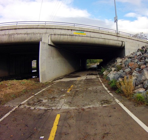
I figured wrong. This is me destroying my hubs and bottom bracket underneath Highway 101, which runs just north of the airport.
This is a case of me saying “Do as I say, not as I do.” You shouldn’t bike through deep water like that if you can help it. I need to remove water from the frame and inside the wheels, and I’ll spend this weekend cleaning out my hubs and bottom bracket. The other problem is hidden underwater obstructions can take you down without warning. I’ve been there, done that, maybe should make a t-shirt.
And I really should know better. This Highway 101 undercrossing is a frequent trouble spot. With all of the dredging the Santa Clara Water District did earlier this year, though, I thought conditions would be better.
Crossings south of 101 (i.e. between the Green Island Bridge at the north end of the airport to downtown San Jose) was clear for travel last night. The crossings north of the airport (i.e. 101, Trimble, Montague Expressway, and Tasman) were flooded.
The good news is that the water subsides quickly — all of these low spots were mostly open this morning, with minimal standing water along with some mud and debris.
For tonight and Friday, the National Weather Service has issued a high wind advisory for much of the San Francisco Bay Area. This means winds exceeding 35 MPH are expected in the advisory area shown in the map below.

Gusts approaching 70 MPH are forecast at elevations from 900 to 2500 feet in the North Bay Mountains, East Bay Hills, and Diablo Range. These strong winds will be from the north / northeast, so plan your Strava KOMs accordingly be careful and watch for falling trees, downed power lines and flying bike-riding witches.