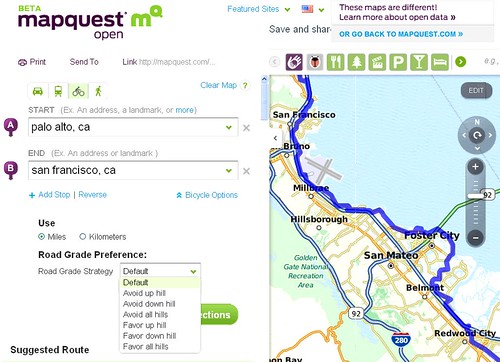
MapQuest adds a bicycle option to the “Open” version of their online directions service.
Over the past year, MapQuest has embraced the OpenStreetMap in a big way, contributing money, time and software development to the project. They started a few open data initiatives of their own, including a MapQuest Open map service that uses OSM data.
On Thursday, MapQuest announced bicycle, pedestrian and transit directions everywhere around the world their directions service is available on MapQuest Open.

For bicycling, I like that there’s an option to specify how much you like hills (or not).
It’s important to remember the routing is based on user contributed street, road and bike facility data. While some small areas are reasonably complete, big swaths of the United States have incomplete data compared to much of Europe.
OSM also doesn’t have the 15,000 miles of bike path information that was compiled by volunteeers and then gifted to Google by the Rails to Trails Conservancy, so MapQuest’s directions will miss bike trails outside of areas with active OSM mapping enthusiasts. I asked Rails to Trails to contribute their collection of crowd-source map data to OSM as well. Their answer: “We’re thinking about it.”
This limited information leads to some frustration with MapQuest Open Directions failing to find directions. MapQuest’s Open name service is a little goofy sometimes too — when I want directions to Santa Cruz, for example, the map takes me to Santa Cruz County. Even when I specify Beach Street or Pacific Avenue, it asks me to choose between the street of that name in Santa Cruz or in Monterey County. (MapQuest’Open name service quirks is the reason I went with Google’s geocoding service when I created my bike routing application that otherwise uses MapQuest and OSM routing.)
Bike Directions in Oceania, Asia, Europe and Africa
Where MapQuest Open directions can shine is outside of North America. The directions service works for Australia and New Zealand, for example. New Zealand OSM data is perhaps less complete than that of the USA right now, but they have a very active effort in place now to convert government provide data into OSM.
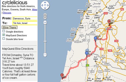
I didn’t notice this until now, but MapQuest Open bike directions now even works for Asia and parts of Africa, including in the Russian Far East, Japan, South Korea, China (the PRC and the ROC), Afghanistan, South Africa and Egypt. It’s unable to calculate a route between Cairo and Tripoli, unfortunately, but if you want a route from Damascus to Tel Aviv, MapQuest is happy to oblige.
And tooting my own horn, this additional Asia coverage also works for my own mapping service, which uses MapQuest and OSM for it’s bicycle routing.
US Transit Routes
The other part of MapQuest’s announcement was the inclusion of transit directions for New York, Chicago, Washington, D.C., Boston, Philadelphia and San Francisco.
For San Francisco, MapQuest has schedules and routes for SF Muni, BART, and Caltrain, and MapQuest is able to link all three systems together for a trip, for example, from San Jose Diridon to Union City BART using Caltrain, Muni N-Judah to Embarcadero Station, and BART to the East Bay.

Good spot, Fritz.
My mapping expert tells me MapQuest is putting quite a bit of money into OpenStreetMap core stuff at the moment and doing a good job of OSM. The namefinder improvements recently have been funded by them for instance.
But it’s odd that MapQuest don’t seem to have route type options, or ability to input zipcodes/postcodes.
And no app option yet, which is critical if a journey planner is going to be useful on-the-fly. Journey planner web interfaces on smartphones aren’t so hot.
Also surprised MapQuest doesn’t take account of hills automatically. The BikeHub app does this.
One of the next updates for the app, from routing engine experts at Cyclestreets, will be advanced routing data like surface type (good asphalt, cobbled streets, muddy trails etc).
And Bike Hub cycle-specific satnav app will soon also get A to A routing for circular leisure ride routing, with sticky PoIs such as churches, stately homes, National Trust properties etc.
All in all, it’s a very exciting time to be involved in cycle journey planning (and I applaud your coding work in this respect).
It is cool that they are working on this however like most of these bike maps it does not give Bike commuters direct routes to destinations. They give routes that go way out of the way. When I put in my home address and my work address it turned my 7.63 mile route into a 42.5 mile loop around the city. I posted feed back so maybe Mapquest will resolve this.
@Johnny – yeah, right now MapQuest seems to have problems with certain routes that don’t seem based on the map data. This32 mile trip, for example, should only be 8 miles, and if I move the start point just a little the routing works as expected.
MapQuest was the early innovator in online mapping, but they rested on their laurels as Google, Yahoo and Microsoft surpassed them. I counted MapQuest out of the game, so I’m very excited to see this kind of movement from them again and provide a little competition for Google and the others.
What’s most exciting — they’re amazingly open to user input via their open initiative developer forums. I and others asked for adjustable weighting on bike facilities and path grade about three months ago and *boom* those features are available now.
I’m looking forward to the BikeHub updates. When will this start working in North America? 🙂
Can you share that request forum link again? Can’t find it now.
Hey Andy, right here: http://developer.mapquest.com/web/products/open/forums/-/message_boards/message/156988
Not exactly easy to find, is it?
Hi Richard. I am little able to understand above. (Sorry, I have little time to read and understand them now). But I will try to use it for my blog.^^ Thank you for your info. shuichi