Category: san jose

Begin 2017 with San Jose Bike Train

Happy New Year, all. San Jose Bike Train rolls this coming Wednesday, January 4, 2017 at 8:15 A.M.

If you can make your way to the vicinity of downtown San Jose, join us the first week of 2017 at Caffe Bel Bacio located directly on the Guadalupe River Trail between Julian and St James Streets in San Jose’s Little Italy.

San Jose Bike Train Route

Over the past couple of years we’ve kind of evolved into a coffee klatch. I and others are generally at the coffee shop by 8 A.M., then we depart at 8:15 for a casual, slow-paced group ride along the trail to destinations north.

Shopping mall bike lockers

Christmas shopping apparently began early for many people, with crowds reportedly trapped in the parking garage for up to three hours at one popular shopping mall in Silicon Valley, California before the Thanksgiving Holiday. Some shoppers at Westfield Valley Fair abandoned their cars, walked out to the street and Ubered their way home.

Valley Fair Mall doesn’t advertise this among their travel options, but they provide the best bike parking I’ve seen at an American shopping mall — free, secure bike lockers.

Valley Fair Mall bike facilities

(more…)

Los Gatos Creek Trail audit in the rain

I need to improve the data for Los Gatos Creek Trail (LGCT) on this trail flooding status page for Santa Clara County, California, so I plan to ride LGCT in the middle of the rainstorm expected on Friday. Who wants to join me for this ride?

Leigh Avenue is the street immediately west of Blackford Elementary School, where many trail users cut through the parking lot to access Willow Street. Here’s a storm drain on Leigh immediately over the Los Gatos Creek Trail.

Leigh Avenue storm drain dumps to Los Gatos Creek Trail.

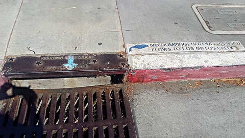
This drain collects significant runoff from the street, along with some from the school parking lot. Frequent trail users likely already know that this drain dumps onto the trail below.

Leigh Avenue storm drain dumps to Los Gatos Creek Trail.

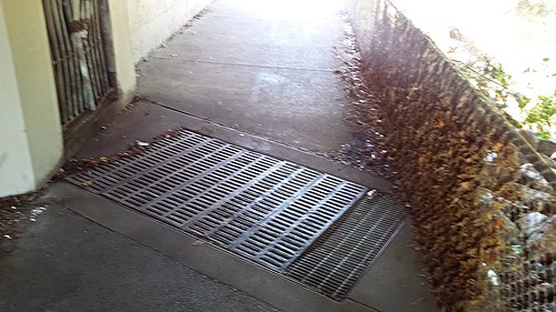
Theoretically, the water should flow from that outlet against the wall directly down into that grate below. The leaves plastered into the chainlink fence hint at the reality — trail users must push through a waist-deep torrent.

This trail is well above the creek, even at undercrossings. Besides Leigh Avenue, the only other problem spot I’m aware of is a low spot near Vasona Park. I’ll decide Friday morning if I want to backtrack into Los Gatos to check flooding at that location.

I’d like to shoot photos and video of the torrent as it occurs for advocacy purpose. A human subject in these images would be great. Ping me if you think you can join me somewhere along the way. I plan to be in Campbell about 8 A.M. on Friday for this ride, and will probably get to Leigh around 8:30. You can expect you and your bike to get soaked during this ride, so bring a towel.

Attention SF Bay Area: “Atmospheric River” on the way, possible heavy rain

It’s time to refresh the waterproofing on your rain gear and ensure your fenders are in good shape. The National Weather Service tells us to expect rain beginning Thursday night to Friday as an “atmospheric river” of moist air arrives, with another system moving in for additional rain over the weekend.

Atomospheric River October 2016 rain forecast NWS Bay Area

For those riding Santa Clara County trails, look for real-time trail flooding status here.

Atmospheric River image courtesy National Weather Service Bay Area.

Vision Zero, Data driven enforcement, and Discrimination?

The Safe Routes Partnership moderated a Twitter chat this morning on the topic of equity and law enforcement in the context of active transportation. Among the good discussion starters, the Safe Routes Partnership asked:

(more…)