Sal Pizarro writes about the 250 Adobe employees who make 1600 trips each month by bike at Adobe’s headquarters in downtown San Jose.

Posted In san jose
Sal Pizarro writes about the 250 Adobe employees who make 1600 trips each month by bike at Adobe’s headquarters in downtown San Jose.
On Tuesday afternoon, San Jose Police reported the city’s first fatality of a person riding a bicycle.
SJPD currently investigating a fatal collision involving a vehicle vs. bicyclist at Leigh Ave and Coit Dr. Please expect traffic delays.
— San Jose Police Dept (@SanJosePD) March 21, 2017
According to the Mercury News, the crash occurred at 2:52 PM, police are investigating, the driver is cooperating.
This portion of Leigh Avenue is an important North-South connector between the central part of San Jose and Los Gatos across South San Jose. I travel here somewhat frequently, and the Strava global heatmap also signals the popularity of this bike-laned road.
In spite of the 35 MPH speed limit and the presence of children from nearby schools (class dismissed from Fanmatre Elementary School 500 feet from the collision site a mere 10 minutes before the collision happened, so children undoubtedly witnessed this crash), people speed like maniacs down Leigh Avenue. The street looks like a freeway, after all.

From 2006 through 2013, nine people on bikes and another nine people on foot have been injured after they were hit by a car within half a mile of this intersection.

The Silicon Valley Bicycle Coalition San Jose Team meets tonight at the bike coalition office. I’ve requested a moment for the unidentified victim of yesterday’s traffic violence.
Other items on tonight’s agenda:
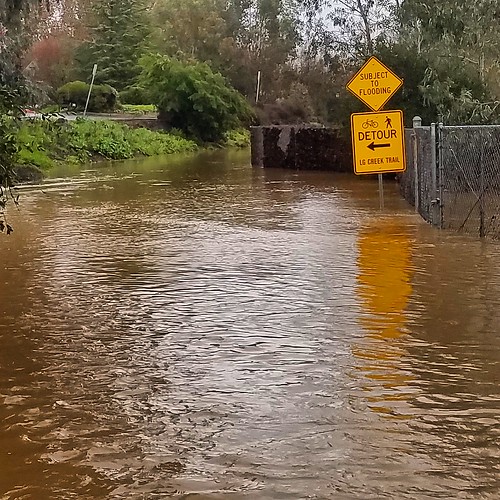
Many of our creekside trails have been underwater for several weeks after this season’s epic winter storms. The rivers are finally subsiding, exposing a mess of mud and debris. Maybe you can’t donate $5 million in flood relief like self-made billionaire Kieu Hoang did last week, but you can spare ten bucks for a shovel, or $80 for a chainsaw, or even an hour or two of your time this weekend.

Update: The Guadalupe River Trial under Highway 101 is (more or less) passable. The real problem spot now is the trail under Montague Expressway. We’ll work there this Saturday, March 11, 2017 from 11 a.m. to 1 p.m.
This chart from the United States Geological Survey shows the level of the Guadalupe River underneath Highway 101 just north of San Jose International Airport. The trail floods here at any level over seven feet deep.

Over the past few days the river level has dropped by about an inch per day. At this pace, the trail should be above the water in about ten days, but the trail will still remain covered in mud and debris.
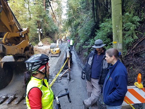
City of San Jose and Valley Water District crews are still incredibly busy cleaning up and repairing significant flood damage elsewhere in the area, so we’re on our own for the time being cleaning up the trail. Because Hwy 101 is the most significant barrier to bike travel, I’d like to start with that underpass. If the water level drops enough, I tentatively plan to bring a shovel here the morning of Saturday, March 11. Many hands make light work, so I invite you to come along to help.
Bobcat loader rental runs about $200 / day. If somebody wants to rent one and trailer it to this location I’ll pitch in for the cost. Let me know immediately if you can do that so I can contact the city, the airport, and the water district about whatever permits we might need to get this done.
I’ll bike here, but if you drive remember that airport parking costs money ($15/day at the Economy Lot, located right next to the trail). Nearest free parking is street parking on Airport Parkway about a one mile walk away, but those spots are usually filled up with sleeping uber and Lyft drivers.
Let me know if you think you can participate. I’ll bring water and snacks, maybe figure out a way to get pizza delivery here. Bring your own shovel and rubber boots. And if it turns out city and water district crews get a chance to clean this up for us, I’ll cancel this volunteer effort.
With record-breaking rainfall throughout Northern California abating for now, a bunch of us will be tempted to hit the roads on our bikes. Several favorite road cycling roads are closed, including Mount Hamilton Road, Niles Canyon, Soquel-San Jose, and more.
These lists show county-maintained roads only; city roads are the responsibility of their respective cities. Numerous state highways have also been impacted by the storms; online traffic maps seem to mostly track those fairly well, or you can go straight to the source at Caltrans Quickmap.
Even if roads are thought to be open, keep your eyes peeled for hazards. While riding in the Santa Cruz Mountains two weekends ago, a tree feel in front of me as I descended Glenwood Road at about 30 MPH. I grabbed brakes and stopped in time, but the next thing I know power lines are hanging on either side of me. That was incredibly sketchy, as was gingerly threading my way out of that web like a jewel thief maneuvering a bicycle-shaped treasure through a laser-protected vault.
Conversely, some closed roads are vaguely bike-passable, though you may need to portage your bike across chasms, creeks, and downed trees on occasion. If you’re tempted to schlep through mud to get past a road, consider this (slightly grody) cautionary tale from Janeen, who bikes most days from Santa Cruz to work in Morgan Hill.
Every South Bay bike path I track here is currently unusable due to flooding. Even Stevens Creek, which normally stays fairly dry, is impassable under Highway 101. Portions of the trail along Coyote Creek are completely inundated along with U.S. Highway 101 in Morgan Hill.
I’ll try to update my own local road closure map sometime Tuesday night. Weather should remain clear Wednesday through Friday, with another atmospheric river expected this Saturday afternoon.
I’m biking over the Santa Cruz Mountains Wednesday morning (via Mountain Charlie and Old Santa Cruz Highway, both of which are reported as open) and will give a report.