A recently published study shows bike commuters in Fort Collins, Colorado can reduce exposure to some, but not all, air pollutants by riding their bikes on side streets during commute times.
Posted In news
Yesterday was local election day in California and around the nation. For the areas I generally pay attention to, most elections were for school districts, special purpose districts, and bond measures to fund schools.
From a transportation and land use perspective, several interesting issues in San Francisco bolstered turnout to 30%, which is more than double the statewide turnout.
Update: The Santa Clara County Coroner identified the victim of yesterday’s Page Mill Road fatal collision as 52-year-old Jeffrey Donnelly of Palo Alto, CA. He leaves behind a wife and three children.
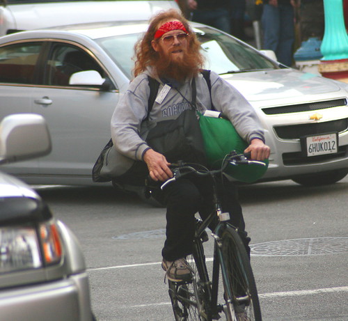
I count three vehicle-vs-bicycle crashes this morning in the San Francisco Bay Area, including a fatality on Page Mill Road just north of I-280 in Los Altos Hills.

According to the Redwood City office of the California Highway Patrol, a southbound cyclist was merging onto Page Mill Road from Old Page Mill Road immediately north of I-280 when he was struck by the southbound driver of a black Volkswagen Jetta at Christopher Lane. The call came in 6:53 AM on Tuesday, November 3 2015.
Note: Earlier today, I incorrectly reported the location as Page Mill at Foothill Expressway. The collision location was Page Mill Road at Christopher Lane, immediately north of I-280.
Cyclist killed on Page Mill Road at entrance to NB 280 at border of #LosAltos and #PaloAlto. pic.twitter.com/OGEyXwBrUH
— Matt Keller (@MattKellerABC7) November 3, 2015
The turn from Old Page Mill onto Page Mill becomes an off-ramp going to northbound I-280. To fix this nasty bit of work, Santa Clara County Roads proposes safety improvements to this interchange to avoid exactly this type of collision. .Los Altos Hills residents, however, have fought this safety project because they say it will erode the rural character of their town and negatively impact property values. The median home value in Los Altos Hills has shot up 18.4% over the past year to $4.2 million, so I can understand their concern.
CHP dispatch shows an ambulance was called for a vehicle-vs-bike collision on Alameda De Las Pulgas at Cedar Avenue in West Menlo Park, CA. No further details are available, but this happened just as children are going to school at Los Alamitos Elementary just a few blocks away. Residents in this area complained about dangerous traffic on this street at a town hall meeting just last night.
Finally, the driver of a school bus apparently hit a cyclist this morning on Geneva Avenue at Delano in San Francisco.
It wasn’t just cyclists having a bad day in the Bay Area, with multiple sigalerts on several regional freeways. I-880 through San Jose was closed at Brokaw (jackknifed truck) and at 237 (motorcycle wreck). The Benecia Bridge was closed much of this morning because of an injury crash. Serious, multi-car collisions also took place on Highway 101 at Hellyer in San Jose, and in San Mateo at 3rd Avenue.
Drive safely and keep your eyes off the phone and on the road, please!
The Adobe Creek viaduct under Highway 101 connecting the Bay Trail with the city of Palo Alto normally closes on October 15 due to winter flooding. No rain means no flooding, so the city Public Works Department announced the trail will remain open for now, although it will be subject to closing at any time without notice in the event of sudden rainfall.
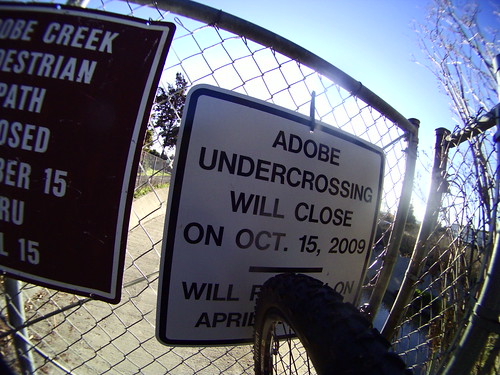
The city of Palo Alto plans to build an overcrossing to replace this flood-prone undercrossing and provide year-round bicycle and pedestrian access over Highway 101 in 2017.
Check the Santa Clara County Trail Status Page for stream levels at various locations throughout Santa Clara County. The rainfall portion of that is currently broken due to API changes, but I’ll have that fixed before the rain begins in earnest in a couple of months.
Thank you to local bike educator Richard Swent for the notice.
The League of American Bicyclists (LAB) released their third annual “Where We Ride” report yesterday in which they crunch the numbers from the 2014 US Census American Community Survey.

As LAB report notes, “There are at least two limitations to the data: 1) it only measures how someone usually gets to work in the last week before the question was asked, and 2) it only captures the mode used for the most distance. These limitations mean that occasional bike commuters and multimodal commuters who use bikes are unlikely to be captured by ACS data.”
In San Francisco, for example, the ACS data comes nowhere close to counting all of the people who ride bikes to work. Thousands of people either bike in from neighboring counties, or they bring their bikes onboard transit services from those other counties.
The other weakness is the ACS data does not capture all bike trips. If you bike to school, to the cafe, to the store, or for recreation, your trip is not captured in this survey. You have to find this other travel information at either the National Household Travel Survey, which captures travel with multiple modes for all reasons at the national level, or the California Household Travel Survey for California. Both of these are large, occasional surveys; California, for example, collects statewide travel data once a decade. Perhaps a clever data scientist has found a way to predict actual bike usage from the ACS data by finding correlations with the travel survey data and the handful of city traffic counts that now include biking information.
With all of those disclaimers out of the way, I think the data is useful to capture large trends. You can read the report here.
To encourage you to read the report, I’ll have a trivia quiz with a GIVEAWAY tomorrow. I’ll have one simple question that I will post Friday late morning (California time); the first to answer it correctly wins a copy of the brand new Horton Collection book Shoulder to Shoulder: Bicycle Racing in the Age of Anquetil or an Amazon gift card if you live outside of the USA.